Climate Change Impacts, Exposure and Vulnerability

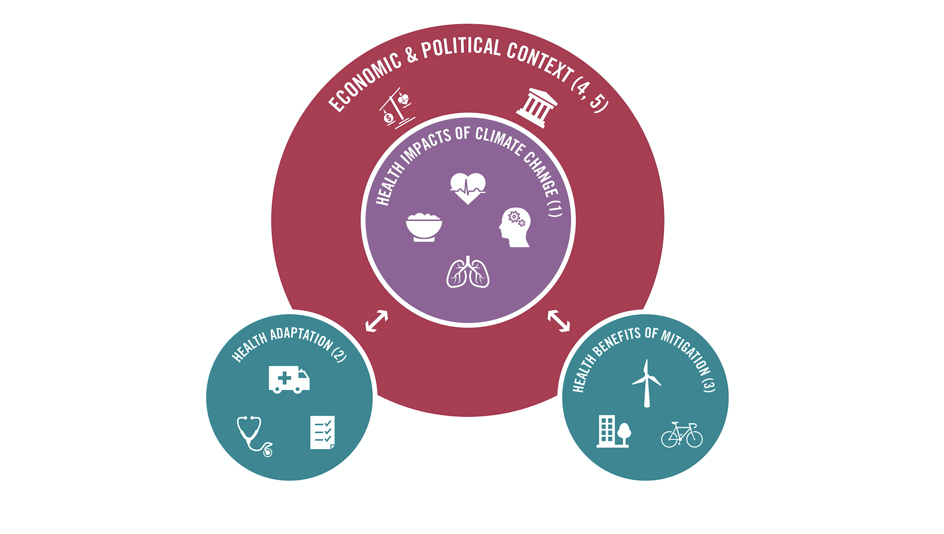
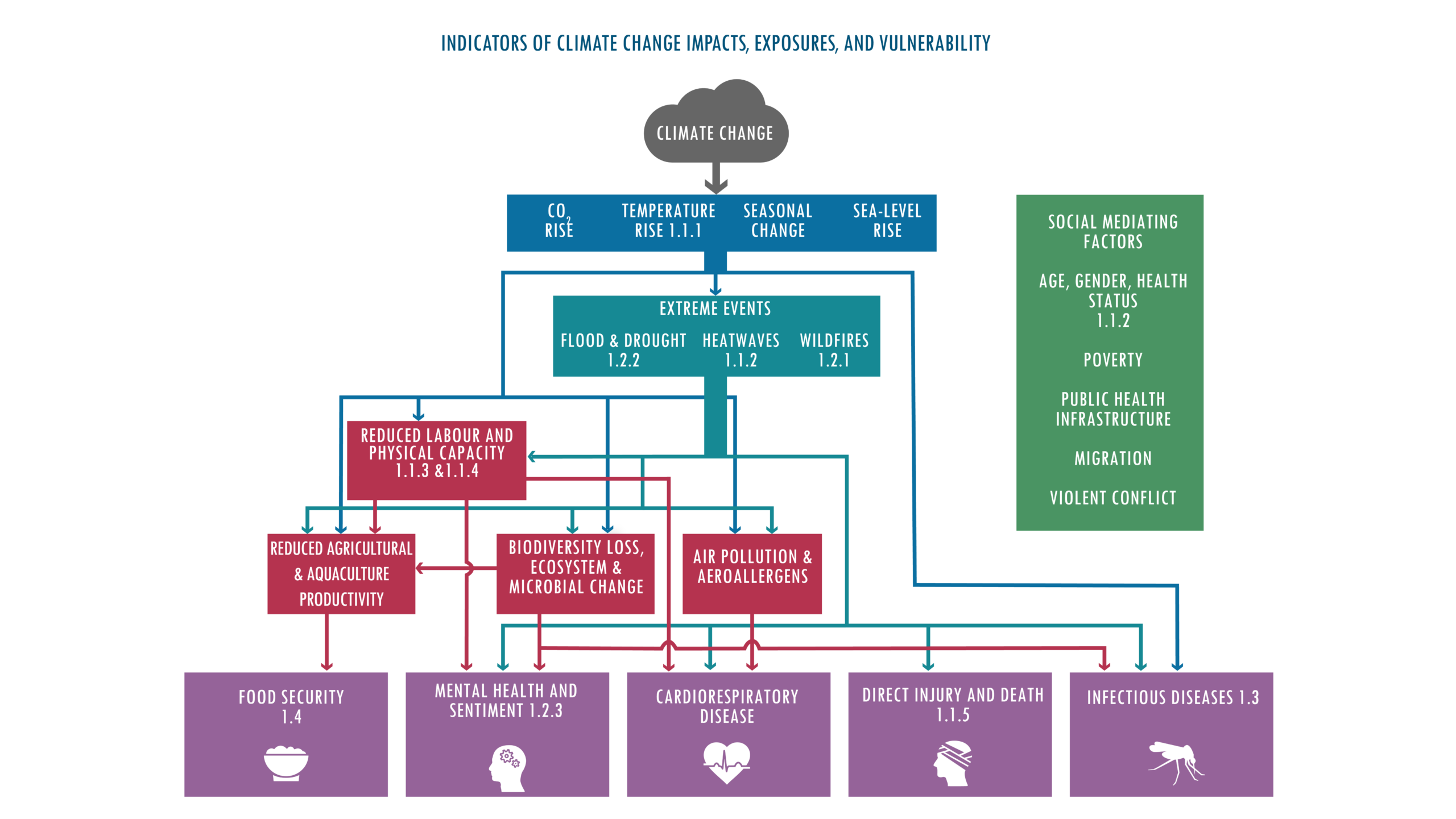
A changing climate has profound implications for human health, with more frequent heatwaves and extreme weather events, changing patterns of infectious disease, and the exacerbation of existing health challenges around the world. Indicators in this section track how these impact on human health.

View fullscreen:

1.1 Health and Heat

A changing climate has profound implications for human health, with more frequent heatwaves and extreme weather events, changing patterns of infectious disease, and the exacerbation of existing health challenges around the world. Indicators in this section track how these impact on human health.

View fullscreen:

1.1.1: Exposure to Heating

This indicator shows the temperatures that humans were exposed to during their respective summer seasons. Using population weighted exposure takes into account the fact that inhabited land areas, in particular urban areas, experience warming at a faster rate than oceans.

View fullscreen:

Headline finding

From 1986-2005 to 2022, populations were exposed to an average increase in summer temperature three times the global mean.

Data sources

1. European Centre for Medium-Range Weather Forecasts Reanalysis 5th Generation monthly averaged data on single levels from 1959 to present. Copernicus Climate Change Service Climate Data Store. Accessed in 2023.

2. Gridded Population of the World Version 4, 2021. Socioeconomic Data and Applications Center, National Aeronautics and Space Administration.

3. Historical, Gridded Population dataset, 2021. The Inter-Sectoral Impact Model Intercomparison Project.

Caveats

This indicator reports changes in summer temperatures but does not capture the existence or absence of effective adaptation measures, such as heat early warning systems, cooling devices, and green areas in cities.

This indicator was last updated in September 2023

Indicator description

This indicator tracks changes in summer temperatures relative to the 1985-2005 average. By overlapping gridded temperature and population data, this indicator shows that inhabited land areas experience faster warming than oceans and highlights that human populations are being exposed to increased temperatures in summer months.

Indicator author

Dr Jonathan Chambers

1.1.2 Exposure of Vulnerable Populations to Heatwaves

Exposure to extreme heat has a range of health consequences including, heat stress and heat stroke, worsening heart disease, and acute kidney injury. Infants and older adults are particularly vulnerable to adverse health effects from heat exposure and are being increasingly exposed to heatwaves, defined as a period of 2 or more days where both the minimum and maximum temperatures are above the 95th percentile of 1986–2005. This indicator tracks the number of heatwave days and the exposure of these vulnerable populations, those under 1 and over 65, to heatwaves.

View fullscreen:

Headline finding

In 2013-2022, infants and people over 65 experienced, on average, 108% more days of heatwave per year than in 1986-2005.

Data Sources

1. European Centre for Medium-Range Weather Forecasts Reanalysis 5th Generation monthly averaged data on single levels from 1959 to present. Copernicus Climate Change Service Climate Data Store. Accessed in 2023.

2. The Inter-Sectoral Impact Model Intercomparison Project. ISIMP3b Bias Adjustment. 2022.

3. Hybrid gridded demographic data for the world, 1950-2020 0.25˚ resolution, 2022. Chambers, J.

4. 2020 Revision of World Population Prospects. United Nations.

5. A global downscaled age structure data set for assessing human impacts of climate change, 1970-2100, 2021. Briggs, DJ.

Caveats

As two distinct sources were used for population data to obtain estimates of both the spatial and temporal characteristics there may be some inconsistencies between the pre and post 2000 values.

This indicator was last updated in September 2023

Indicator description

This indicator tracks changes in the number of heatwave days per year per vulnerable person and reflects the exposure of vulnerable populations to heatwaves expressed as person-days, this captures increasing durations of heatwaves as well as changes in frequency compared with the average number of events in the reference period (1986–2005).

Indicator author

Dr Jonathan Chambers

1.1.3 Heat and Physical Activity

Physical activity is key to good health and wellbeing. Hot weather reduces the likelihood of engaging in exercise and increases heat illness risk when it is undertaken. This indicator tracks the impact of a warming world on the number of hours of physical activity potentially lost due to heat.

View fullscreen:

Headline finding

In 2013-2022, compared to 1991-2000, there were 241 additional hours annually, during which ambient heat posed a moderate or higher risk of heat stress during light outdoor physical activity.

Data Sources

1. European Centre for Medium-Range Weather Forecasts Reanalysis 5th Generation monthly averaged data on single levels from 1959 to present. Copernicus Climate Change Service Climate Data Store. Accessed in 2022.

2. Gridded Population of the World Version 4, 2021. Socioeconomic Data and Applications Center, National Aeronautics and Space Administration.

3. The Inter-Sectoral Impact Model Intercomparison Project. ISIMP3b Bias Adjustment. 2022.

Caveats

The estimation of heat stress risk for a given exercise category may not be uniform across the entire population, and risk estimates in particular may be different for older adults, young children, pregnant women, and those living with disabilities or chronic diseases. A more detailed interpretation model of heat effects on exercise would incorporate individual factors such as age, health status, physiology, and clothing.

This indicator was last updated in September 2023

Indicator description

This indicator incorporates temperature, humidity, and solar radiation restricting analysis to local sunlight hours only to estimate and track the daily hours per person during which undertaking outdoor physcial activity would pose a heightened heat stress risk. The indicator uses “moderate” heat stress risk, as defined by the 2021 Sports Medicine Australia Extreme Heat Policy, which stratifies estimated heat stress risk based on ambient temperature and relative humidity.

Indicator authors

Dr Troy J Cross, Dr Samuel H Gunther, Prof Ollie Jay, Dr Jason KW Lee

1.1.4 Change in Labour Capacity

Our capacity to work is affected by temperature and humidity, particularly in highly physical jobs in poorly coolled environments or outdoors with little to no shade in agriculture, industry, and manufacturing sectors. Reduced work productivity puts a strain on the socioeconomic determinants of health for individuals and communities. As the world continues to warm, this indicator tracks the change in potential work hours lost due to exposure to high temperatures.

View fullscreen:

Headline findings

Heat exposure led to the loss of 490 billion potential labour hours in 2022, a nearly 42% increase from 1991–2000.

Data Sources

1. European Centre for Medium-Range Weather Forecasts Reanalysis 5th Generation monthly averaged data on single levels from 1959 to present. Copernicus Climate Change Service Climate Data Store. Accessed in 2022.

2. Gridded Population of the World Version 4, 2021. Socioeconomic Data and Applications Center, National Aeronautics and Space Administration.

3. International Labour Organization International Statistics Database (ILOSTAT). ILO. Accessed in 2023

4. The Inter-Sectoral Impact Model Intercomparison Project. ISIMP3b Bias Adjustment. 2022.

5. Global, regional, national, and subnational occupational exposure to solar ultraviolet radiation for 195 countries/areas, and the global, regional, and national attributable burden of non-melanoma skin cancer for 183 countries, 2000-2019: a systematic analysis from WHO/ILO Joint Estimates of the Work-related Burden of Disease and Injury. 2023. Pega F, Momen NC, Stricher KN et al.

Caveats

The distribution of agricultural, construction manufacturing, and service sector workers used are country averages, applied evenly to the population of each grid cell, thus not accounting for sub-national variation in industry sector.

The numbers and percentages of workers captures those in the formal economy for regions and countries, unpaid work, to which women often dedicate more time than men, is not accounted for.

This indicator was last updated in June 2024

Indicator description

This indicator calculates hours of work lost as a result of heat exposure in four sectors: agriculture, construction, manufacturing, and service. It monitors potential hours lost by linking Wet Bulb Globe Temperature (including temperature, humidity and solar radiation) with the amount of energy expended by workers through the typical metabolic rate of workers. It then combines this calculation with the proportion of people working over 15 years old in each of the four sectors in each country to estimate the potential work hours lost per year.

Indicator authors

Work hours lost: Chris Freyberg, Dr Bruno Lemke, Matthias Otto

Number of outdoor workers: Dr Natalie C. Momen, Dr Frank Pega

1.1.5 Heat-Related Mortality

Populations are finding themselves increasingly vulnerable to extreme heat. Exposure to extremes of heat can result in a range of health consequences, including heat stress and heat stroke, worsening heart disease, and acute kidney injury and leads to an increase in all-cause mortality with people aged over 65 particularly vulnerable to these effects. As the world continues to warm and populations age, this indicator tracks the proportion of stressfully warm days that were made more likely by human-induced climate change and tracks heat-related mortality in over 65 populations around the world.

View fullscreen:

Headline findings

In 2018-2022, people experienced on average 86 days of health-threatening high temperatures annually. 60% of such temperatures were made more than twice as likely to occur by human-caused climate change

Data Sources

1. European Centre for Medium-Range Weather Forecasts Reanalysis 5th Generation monthly averaged data on single levels from 1959 to present. Copernicus Climate Change Service Climate Data Store. Accessed in 2023.

2. Gridded Population of the World Version 4, 2021. Socioeconomic Data and Applications Center, National Aeronautics and Space Administration.

3. Historical, Gridded Population dataset, 2021. The Inter-Sectoral Impact Model Intercomparison Project.

4. 2022 Revision of World Population Prospects, 2022. United Nations.

5. 2019 Global Burden of Disease Study, 2020. Institute for Health Metrics and Evaluation.

6. The Inter-Sectoral Impact Model Intercomparison Project. ISIMP3b Bias Adjustment. 2022.

Caveats

The analysis for heat-related mortality assumes the exposure-response function is constant. It does not capture changes in response to heat exposure that might happen over time, as a result of acclimation and adaptation. Not capturing these changes could result in an over-estimation of heat-related deaths in later calendar years. Annual average mortality rates are used, rather than daily mortality rates. Given baseline mortality can be higher in colder months, this may lead to an overestimation of overall mortalities.

This indicator was last updated in September 2023

Indicator description

This indicator tracks days in which temperatures exceeded healthy, safe levels and heat-related deaths are likely to increase (above the 83·6th percentile of temperatures in 1986–2005), how many of these were made more likely by anthropogenic climate change, and global heat-related mortality in populations older than 65 years. It applies the exposure-response function and optimum temperature described by Honda and colleagues (2014) to the daily maximum temperature exposure of the population older than 65 years to estimate the attributable fraction and therefore the deaths attributable to heat exposure compared to the baseline 1991-2000.

Indicator authors

Attribution of human exposure to health-threatening temperatures: Dr Andrew Pershing

Heat-related: Dr Zhao Liu

1.2 Health and Extreme Weather-related Events

View fullscreen:

1.2.1 Wildfires

Wildfires cause a range of health impacts, from direct thermal injuries through to exacerbation of acute and chronic lung disease from smoke and pollution, in addition to the loss of essential and health-supporting physical infrastructures and emergency services. They often cause substantial social and economic impacts. Climate change-driven increases in temperature and changes in rainfall patterns are increasing the intensity, frequency, duration, of life-threatening weather-related events and increasing the risk of wildfires. This indicator monitors change in wildfire danger and the number of people exposed to wildfires and wildfire smoke, globally. With updated methodology, this indicator no longer captures non-fire hot spots such as industry-related recordings increasing the accuracy.

View fullscreen:

Headline findings

The number of days in which people were exposed to very or extremely high fire danger increased in 57% of countries between 2003–2007 and 2018–2022. However, exposure to wildfires decreased in 66 countries and increased in only seven during this period.

Caveats

The fire danger index is calculated based on meteorological parameters, representing potential fire risk not actual fire events. Actual fire events can be influenced through exacerbation or attenuation by anthropogenic factors, such as human-induced land use and land cover changes, industrial-scale fire suppression, and human induced ignition. Moderate Resolution Imaging Spectroradiometer observations are limited by cloud obscuration and sensitivity of the instrument which can limit the fires observed if there are clouds or the fire is too small.

Data sources

1. Moderate Resolution Imaging Spectroradiometer Collection 61, 2022. National Aeronautics and Space Administration Fire Information for Resource Management System.

2. Global 1-km Cloud Cover, 2023. EarthEnv.

3. Fire Danger Indices Historical Data. Copernicus Emergency Management Service, Copernicus Climate Change Service Climate Data Store. Accessed in 2023.

4. Gridded Population of the World Version 4, 2021. Socioeconomic Data and Applications Center, National Aeronautics and Space Administration.

5. Hybrid gridded demographic data for the world, 1950-2020 0.25˚ resolution, 2022. Chambers, J.

6. Global 1-km Downscaled Urban Land Extent Projection and Base Year Grids by SSP Scenarios, 2000-2100, 2021. Gao J, Pesaresi M.

7. Daily Surface Concentration of Fire Related PM2.5 for 2003-2021, 2022. Hänninen R et al., Finnish Meteorological Institute.

8. ECOCLIMAP-II/Europe, 2013. Faroux, S et al.

Indicator authors

Exposure to wildfires: Dr Yun Hang, Prof Yang Liu

Exposure to wildfire danger: Qiao Zhu

Exposure to wildfire smoke: Risto Hänninen, Dr Rostislav Kouznetsov, Prof Mikhail Sofiev

Indicator description

This indicator uses model-based wildfire danger, satellite-observed exposure, and modelled exposure to wildfire fine particles, accounting for cloud cover in the detection of wildfire spots. It incorporates atmospheric modelling to track exposure to wildfire smoke (PM2.5). Climatological wildfire danger is estimated by combining daily very high or extremely high wildfire danger (a fire danger index score of 5 or 6) with climate and population data. Human exposure to wildfires, in person-days (with one person-day being one person exposed to a wildfire in one day) is tracked using satellite and population data.

1.2.2 Drought

Climate change alters hydrological cycles, tending to make dry areas drier and wet areas wetter. Drought poses multiple risks for health, threatening drinking water supplies and sanitation, crop and livestock productivity, enhancing the risk of wildfires, and potentially leading to forced migration. In many water-insecure settings, women and girls are often the ones charged with collecting water, in areas that face harsh droughts this means further to travel, if water can be sourced at all, putting those women and girls in potential danger of gender violence and physical harms. As climate change alters rainfall patterns and increases temperatures, this indicator tracks the change in months of drought globally showing no continent is unaffected by drought.

View fullscreen:

Headline findings

The global land area affected by extreme drought per year increased from 18% in 1951-1960 to 47% in 2013-2022.

Data sources

1. Global Standardised Precipitation-Evapotranspiration Index Database, 2023. Beguería, S et al.

Caveats

This indicator only captures the impacts of climate change on meteorological drought, but does not capture the impacts of climate change on hydrological or agricultural drought. It also does not measure the direct relationship between a drought and the population living in, or depending on, drought-affected areas.

This indicator was last updated in September 2023

Indicator description

This indicator measures changes in the number of months of extreme meteorological drought, using the 6-monthly Standard Precipitation Evapotranspiration Index, compared with a 1986-2005 baseline.

Indicator author

Dr Marina Romanello

1.2.3 Extreme Weather and Sentiment

Climate change-related increases in extreme weather events, including heatwaves and extreme rainfall, pose diverse risks to mental health globally, ranging from altered affective states to elevated mental health-related hospitalisations and suicidality. As the world continues to warm, this indicator tracks people’s sentiment expressed on social media in relation to extreme weather events.

View fullscreen:

Headline finding

Extreme weather in 2022 was associated with a record 0·53 percentage point reduction in online positive sentiment expression during heatwaves, and a 0·31 percentage point reduction in positive sentiment expression during extreme precipitation days

Data sources

1. European Centre for Medium-Range Weather Forecasts Reanalysis 5th Generation monthly averaged data on single levels from 1959 to present. Copernicus Climate Change Service Climate Data Store. Accessed in 2023.

2. Geolocated Tweets collected via the Twitter Streaming Application Programming Interface. Accessed in 2023.

Caveats

While sentiment is related to mental wellbeing, it should not be confused as a measure of it and should be interpreted as an indicative proxy of the mental implications of extremes of heat. Countries that did not have Twitter broadly available to the public, such as China, were underrepresented despite the addition of Mandarin tweets this year. Furthermore, geo-tagged tweets constituted approximately 2% of all tweets and thus may be somewhat limited in their generalisability due to opt-in geo-localization. The vast majority of the Twitter observations were posted in wealthy countries who have greater access to adaptive amenities and potentially underestimates the sentiments of those most disproportionately exposed to some of the hottest conditions in poorer socioeconomic contexts.

This indicator was last updated in September 2023

Indicator description

This indicator monitors expressed sentiment on Twitter, using billions of geolocated tweets collected between 2015 and 2022. It deploys a multivariate ordinary least squares fixed effects model to estimate the annual effect of heatwaves (as defined in indicator 1.1.2) and extreme precipitation (exceeding the 99th percentile of local daily precipitation), on online sentiment expression. It compares sentiment expression between heatwave days and non-heatwave days and between extremely wet days and non-extremely wet days.

Indicator authors

Dr Kelton Minor, Dr Nick Obradovich

1.3 Climate Suitability for Infectious Disease Transmission

The suitability for transmission of many infectious diseases is influenced by shifts in temperature and precipitation. Dengue is a mosquito-borne disease that can cause febrile illnesses and, in severe cases, organ failure and death, with children under five particularly at risk. Malaria is transmitted by mosquitoes and can cause serious illness and death. Vibrio bacteria are found in brackish marine waters and cause a range of human infections, including gastroenteritis, wound infections, sepsis and cholera. With temperatures changing across the globe, this indicator tracks how this is affecting the climate suitability for these infections.

View fullscreen:

Headline finding

The climatic suitability for the transmission of dengue increased by 11.5% for A. aegypti and 12.0% for A. albopictus from 1951–1960 to 2012–2021; the length of the transmission season for malaria increased by 31.3% and 13.8% in the highlands of the Americas and Africa, respectively, from 1951–1960 to 2012–2021.

Data sources

1. European Centre for Medium-Range Weather Forecasts Reanalysis 5th Generation-Land monthly averaged data from 1981 to present. Copernicus Climate Change Service Climate Data Store. Accessed in 2022.

2. Anthropogenic land-use estimates for the Holocene; History Database of the Global Environment v 3.2, 2017. Klein Goldewijk, K et al.

3. Elevation Data, 2020. University of Washington Joint Institute for the Study of the Atmosphere and Ocean.

4. Copernicus Global Land Service: Land Cover 100m: collection 3: epoch 2019: Globe, 2020. Buchhorn, M et al., Copernicus Global Land Service.

5. Optimum Interpolation 1/4 Degree Daily Sea Surface Temperature Analysis version 2, 2021. National Oceanic and Atmospheric Administration Earth System Research Laboratory.

6. Mercator Ocean Reanalysis, 2021. Copernicus Marine Service.

7. A Database of Global Coastal Conditions, 2021. Castaneda-Guzman, M et al.

8. Gridded Population of the World Version 4. Socioeconomic Data and Applications Center, National Aeronautics and Space Administration. Accessed in 2022.

Caveats

These results are not based on case data. They do not include other potentially important drivers (e.g. globalisation). Control efforts, such as water, sanitation and hygiene programs, and vector control efforts, may help to mitigate these effects. National data presented for vectorial capacity for the transmission of dengue only takes into account the most common Aedes species in each country. Data is not presented for countries for which information on vector presence was not available.

This indicator was last updated in September 2022

Indicator description

This indicator tracks the environmental suitability for the transmission of arboviruses (dengue, chikungunya, and Zika), malaria, and Vibrio bacteria. For arboviruses, it uses an improved model to capture the influence of temperature and rainfall on vectorial capacity and vector abundance, and overlays it with human population density data to estimate the R0 (the expected number of secondary infections resulting from one infected person). The influence of the changing climate on the length of the transmission season for Plasmodium falciparum malaria is tracked with a threshold-based model that incorporates precipitation accumulation, average temperature, and relative humidity. The environmental suitability for infections from Vibrio species incorporates sea surface temperature and salinity, as well as chlorophyll-a for Vibrio cholerae.

1.3.1 Dengue

Changing climatic conditions, such as shifts in seasonal temperatures and precipitation levels, are altering the transmission potential of many vector-, water-, food-, and air-borne infectious diseases. Dengue is a mosquito-borne disease that can cause febrile illnesses and, in severe cases, organ failure and death, with children under five particularly at risk. With temperatures changing across the globe, this indicator tracks how this is affecting the climate suitability for these infections.

View fullscreen:

Headline findings

The transmission potential for dengue by Aedes aegypti and albopictus increased by 42.7% and 39.5%, respectively.

Data sources

1. European Centre for Medium-Range Weather Forecasts Reanalysis 5th Generation-Land monthly averaged data from 1950 to present. Copernicus Climate Change Service Climate Data Store. Accessed in 2023.

2. The Inter-Sectoral Impact Model Intercomparison Project. ISIMP3b Bias Adjustment. 2022.

Caveats

These results are not based on case data, they represent the predicted R0 and the potential for outbreaks. This indicator does not include other potentially important drivers (e.g. globalisation) and control efforts, such as water, sanitation and hygiene programs, and vector control efforts, which may help to mitigate these effects. National data presented for vectorial capacity for the transmission of dengue only takes into account the most common Aedes species in each country. Data is not presented for countries for which information on vector presence was not available.

This indicator was last updated in September 2023.

Indicator description

This indicator tracks the environmental suitability for the transmission of arboviruses (dengue, chikungunya, and Zika). It uses an improved model to capture the influence of temperature and rainfall on vectorial capacity and vector abundance, and overlays it with human population density data to estimate the R0 (the expected number of secondary infections resulting from one infected person).

Indicator authors

Dr Maquins Odhiambo Sewe, Prof Joacim Rocklöv

1.3.2 Malaria

Changing climatic conditions, such as shifts in seasonal temperatures and precipitation levels, are altering the transmission potential of many vector-, water-, food-, and air-borne infectious diseases. Malaria is transmitted by mosquitoes and can cause serious illness and death. With temperatures changing across the globe, this indicator tracks how this is affecting the climate suitability for these infections and the fluctuations in the length of the malaria transmission season using climatic and environmental conditions required by the vector and the parasite.

View fullscreen:

Headline findings

Overall, 9·85% of the land without suitable conditions for transmission of P falciparum in 1951–60 became suitable by 2013–22, whereas 17·34% became suitable for P vivax.

Data sources

1. European Centre for Medium-Range Weather Forecasts Reanalysis 5th Generation-Land monthly averaged data from 1951 to present. Copernicus Climate Change Service Climate Data Store. Accessed in 2023.

2. Elevation Data, 2020. University of Washington Joint Institute for the Study of the Atmosphere and Ocean.

3. Copernicus Global Land Service: Land Cover 100m: collection 3: epoch 2019: Globe, 2020. Buchhorn, M et al., Copernicus Global Land Service

4. The Inter-Sectoral Impact Model Intercomparison Project. ISIMP3b Bias Adjustment. 2022.

Caveats

These results are not based on case data, they represent the climatic suitablity for malaria transmission based on climatic data and consensus thresholds. This indicator models the suitability for transmission, it does not at present take into account control efforts that might limit the impact of climate changes on malaria, however, conversly, the influence that control efforts have could be hampered by an increasingly warm world.

This indicator was last updated in September 2023.

Indicator description

Malaria is widely recognised as a climate-sensitive infectious disease due to the climate sensitivity observed in both the vector, Anopheles mosquitoes, and the Plasmodium parasites. With temperature, precipitation, and relative humidity all climate factors that influence the abundance and feeding cycle rate of Anopheles mosquitoes and temperature also driving the development rate of Plasmodioum parasites within the mosquito vectors. This indicator tracks the influence of the changing climate on the length of the transmission season for Plasmodium falciparum malaria with a threshold-based model that incorporates precipitation accumulation, average temperature, and relative humidity.

Indicator authors

Martín Lotto Batista, Prof Rachel Lowe

1.3.3 Vibrio

Changing climatic conditions, such as shifts in seasonal temperatures and precipitation levels, are altering the transmission potential of many vector-, water-, food-, and air-borne infectious diseases. Vibrio bacteria are found in brackish marine waters and cause a range of human infections, including gastroenteritis, wound infections, sepsis and cholera. With temperatures changing across the globe, this indicator tracks how this is affecting the environmental suitability for pathogenic Vibrio in coastal areas.

View fullscreen:

Headline findings

The coastline suitable for Vibrio spp transmission increased by 329 km annually since 1982.

Data sources

1. Global Ocean OSTIA Sea Surface Temperature and Sea Ice Reprocessed dataset between 1982-2022. Accessed in 2023.

2. Mercator Ocean Reanalysis, 2021. Copernicus Marine Service.

3. AWI-CM-1-1-HR and CNRM-CM6-1-HR sea surface temperatures and sea surface salinity from CMIP6 (2015-2100) SSP126 and SSP370 experiments.

4. The Inter-Sectoral Impact Model Intercomparison Project. ISIMP3b Bias Adjustment. 2022.

5. The World Factbook. 2023. CIA

Caveats

These results are not based on case data, they represent the suitability for pathogenic Vibrio infections on the basis of sea surface temperature and sea surface salinity conditions. This indicator does not include other potentially important drivers (e.g. globalisation).

This indicator was last updated in September 2023.

Indicator description

The environmental suitability for infections from Vibrio species incorporates sea surface temperature and salinity to report the lengths of coastlines in Km that experience suitable conditions for Vibrio infections and the period of time in days per year of suitable conditions for Vibrio infections.

Indicator authors

Prof Jaime Martinez-Urtaza, Prof Jan C. Semenza, Joaquin A. Trinanes

1.3.4 West Nile Virus

Changing climatic conditions, such as shifts in seasonal temperatures and precipitation levels, are altering the transmission potential of many vector-, water-, food-, and air-borne infectious diseases. WNV is a mosquito-transmitted pathogen that can cause severe disease with central nervous system involvement in birds, humans, and other mammals.  With temperatures changing across the globe, this indicator tracks how this is affecting the climate suitability for these infections.

View fullscreen:

Headline findings

The annual average climatic suitability of West Nile virus transmission increased by 4·4% from 1951–60 to 2013–22.

Data sources

1. European Centre for Medium-Range Weather Forecasts Reanalysis 5th Generation-Land monthly averaged data from 1951 to present. Copernicus Climate Change Service Climate Data Store. Accessed in 2023.

2. Transmission of West Nile and five other temperate mosquito-borne viruses peaks at temperatures between 23oC and 26oC. eLife 2020. Shocket MS, Verwillow AB, Numazu MG et al.

Caveats

Although the indicator considers the three key WNV mosquito species Cx. pipiens, Cx. quinquefasciatus, and Cx. tarsalis which enable good spatial coverage, other regionally important species are not included. This indicator uses the climatic impact of temperature on the WNV transmission but as yet does not include other changes in climatic conditions such as altered precipitation patterns and frequency of droughts which can also affect local conditions for WNV mosquitos and transmission.

This indicator was included as a new sub-indicator in September 2023

Indicator description

This indicator tracks the thermal suitability of WNV taking into account the mosquito species-specific responses to temperature and models changes in its basic reproduction number R0 (the expected number of secondary infections resulting from one infected host) driven by the changing climate.

Indicator authors

Julian Heidecke, Prof Joacim Rocklöv, Dr Marina Treskova

1.4 Food Security and Undernutrition

The number of undernourished people worldwide has been steadily increasing since 2014. This indicator uses changes in climate to track risks to marine food security and separately, to track the impact on incidence of food insecurity. Through multiple and interconnected pathways, climate change is exacerbating food insecurity; by undermining crop yields, affecting labour capacity of agricultural workers, elevating coastal sea surface temperatures, reducing oxygenation of the world’s oceans, causing ocean acidification and coral reef bleaching, and disrupting supply chains. As climate change increases temperatures and alters weather patterns impacting food production, this indicator tracks the change in global food insecurity.

View fullscreen:

Headline finding

The higher frequency of heatwave days and drought months in 2021 compared to 1981–2010, is associated with 127 million more people experiencing moderate or severe food insecurity.

Caveats

For the marine food component of the indicator, fish production data was used as a surrogate for fish consumption, whilst this is not a completely accurate assumption, there is no comprehensive alternative source of data for all the investigated countries. For the food insecurity component of the indicator, it is possible that there is recall bias in the survey data and additional bias may have been introduced to interviews during the pandemic because interviews were conducted by phone instead of in-person visits.

Data sources

1. European Centre for Medium-Range Weather Forecasts Reanalysis 5th Generation (ERA5) hourly and monthly climate data (2m air temperature). Copernicus Climate Change Service (C3S) Climate Data Store (CDS). Accessed in 2023.

2. Food and Agricultural Organization of the United Nations Food Insecurity Experience Scale. Accessed in 2023.

3. Ocean Reanalysis System 5 Global Ocean Reanalysis Monthly Data from 1958 to Present, 2023. C3S CDS.

4. Food Balances data, 2021. Food and Agriculture Organization of the United Nations (FAOSTAT).

5. 2019 Global Burden of Disease Study, 2020. Institute for Health Metrics and Evaluation.

Indicator authors

Food insecurity (shown in visuals): Prof Elizabeth Robinson, Dr Shouro Dasgupta

Marine food security: Prof Maziar Moradi-Lakeh, Dr Fereidoon Owfi, Dr Mahnaz Rabbaniha, Prof Meisam Tabatabei

Indicator description

This indicator consists of two sub-indicators that cover food insecurity. The first tracks risks to marine food security by monitoring changes in sea surface temperature and the consumption of farmed- or catch-based fish products. The second sub-indicator tracks the impact of climate change through the number of heatwave days and the frequency of droughts during the four major crop growing seasons in each region and income on the incidence of food insecurity.

Adaptation, Planning, and Resilience for Health

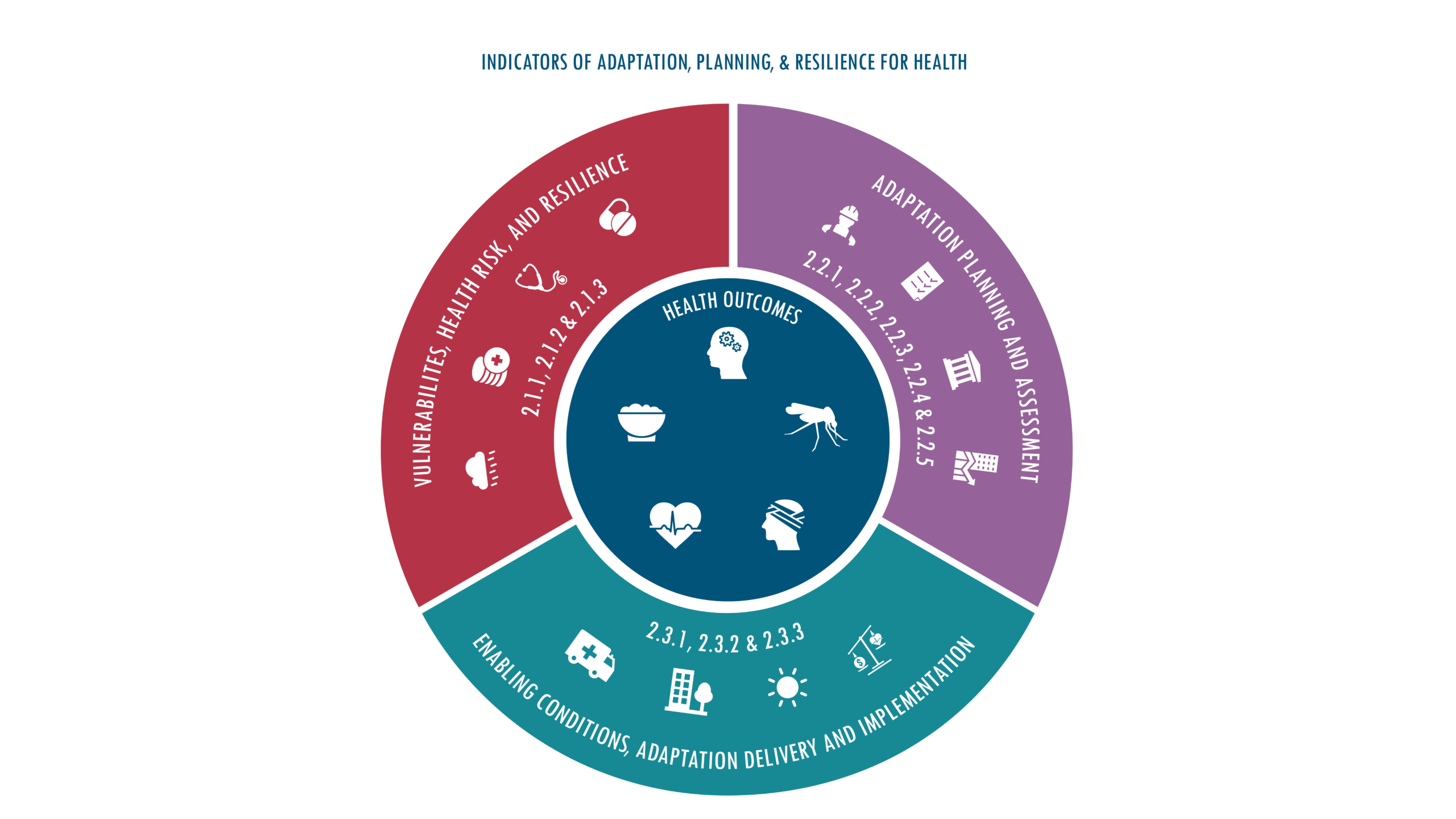
Indicators in this section track how communities, health systems, and governments are understanding the health risks of climate change, the strategies and resources they are deploying, and how adaptation and resilience measures are being implemented globally.

View fullscreen:

2.1 Adaptation Planning and Assessment

Adaptation Planning and Assessment

View fullscreen:

2.1.1 National Assessments of Climate Change Impacts, Vulnerability and Adaptation for Health/2.1.2 National Adaptation Plans for Health

The health impacts of climate change vary by location and population need, vulnerability and adaptation assessments form an essential first step in building local resilience tailored to the location. These indicators tracks the the number of countries that report having conducted a climate change and health vulnerability and adaptation assessment and those with national adaptation plans for health.

View fullscreen:

Headline findings

In 2022, 11 of the 64 countries that committed to building climate-resilient health systems through the COP26 Health Programme reported having completed a vulnerability and adaptation assessment. Between 2020 and 2022, 4 out of these 64 countries developed or updated Health National Adaptation Plans.

Data sources

1. World Health Organization. Alliance for action on climate change and health (ATACH). Accessed 2023

2. 2021 World Health Organization Health (WHO) and Climate Change Global Survey Report, 2021. WHO.

Caveats

The survey sample is not a representative sample of all countries as this survey was voluntary. However, the inclusion of 95 countries despite being conducted during a global pandemic demonstrates substantial global coverage.

Data were pulled and are accurate as of April 30, 2023

Indicator description

This indicator draws on the 2021 World Health Organization (WHO) Health and Climate Country Survey, which was completed by 90 member states and non-member territories with representation from all 6 WHO regions as a baseline for the COP26 commitments with updates on the progress until 2022 coming from regional and country reporting through The Alliance for Transformative Action on Climate and Health (ATACH). It tracks the development of national health and climate change assessments and completion of a health national adaptation plan.

Indicator authors

Dr Diarmid Campbell-Lendrum, Tara Neville

2.1.3 City-Level Climate Change Risk Assessments

Cities and local communities are at the forefront of the health impacts of climate change and must be central to any adaptation response. This indicator tracks the proportion of global cities who have conducted climate change risk assessments and the climate-related health impacts/vulnerabilities that cities identified.

View fullscreen:

Headline findings

In 2022, 94% of cities (848/898) reported they had completed or were undertaking a city-level climate change risk assessment, up from 713 in 2021.

Data sources

1. 2022 Carbon Disclosure Project (CDP) Annual Cities Survey, 2022. CDP.

Caveats

This is a self-reported, non-compulsory survey so data provided may be subjective and response rates can fluctuate, with low uptake in certain areas, particularly the Eastern Mediterranean Region and among cities in low human development index countries.

This indicator was last updated in September 2023

Indicator description

This indicator draws on data from the Carbon Disclosure Project annual Cities Questionnaire, assessing the number of global cities that have undertaken a city-wide climate change risk or vulnerability assessment and the reported climate-related health impacts and vulnerabilities of these cities.

Indicator author

Prof Karyn Morrisey

2.2 Enabling conditions, Adaptation Delivery, and Implementation

View fullscreen:

Headline findings

In 2020, national meteorological and hydrological services of 86 countries reported providing climate information to the health sector; only five of the 86 indicated that these climate services guide health sector policy and investment plans.

Data sources

1. Country Profile database, 2021. WMO

Caveats

This indicator only considers climate services provided by national member states, and not by academic, private, regional, or other providers. The data is self-reported by countries and may therefore include reporting bias.
The WMO survey is an open questionnaire that can be updated at any time by WMO members. Therefore figures reported here may change over the year.


This indicator was last updated in September 2021

Indicator description

This indicator takes data from the World Meteorological Organization Country Profile Database integrated questionnaire, which asks for information regarding which communities and sectors the National Member States provide products and information to and the extent to which these products are used to improve decisions.

2.2.1 Climate Information for Health

Climate services for health are essential to help the health sector conduct research and make climate informed decisions for planning, preparedness, and response to climate-sensitive diseases, extreme weather, and other environmental hazards. They can also provide early warning systems, triggering responses in communication to the public and preparedness of health services and human resources. This indicator tracks the number of national meteorological and hydrological services that are providing services to the health sector.

View fullscreen:

Headline finding

In 2022, 81% (157/193) of WMO’s 193 Members report working with the health sector. The most frequent type of service provided is data (74%; 143/193).

Data sources

1. 2021 World Health Organization (WHO) Health and Climate Change Global Survey Report, 2021. WHO.

Caveats

The current data source from WMO only considers climate services ) national meteorological and hydrological services (NMHS). It is unclear the degree to which other providers, such as academic institutions and research projects, private sector products, products from other Ministries, or regional and global products and services are being used, in proportion to services made available by NMHS. The open questionnaire can be updated at any time by WMO members, therefore the figures reported here may change over the year. As each country may update their profile information at different moments in time, snapshots do not reflect progress for any given year but rather information provided until a certain date.

The current questionnaire does not record the number of WMO members that do not provide climate services to the health sector and as the data is self-reported by countries it may therefore include reporting bias

This indicator was last updated in September 2023

Indicator description

This indicator reports on the number of World Meteorological Organization (WMO) national meteorological and hydrological services (NMHS) providing climate services to the health sector and is calculated based on self-reported information provided by NMHS through the Country Profile Database Integrated questionnaire. The data reflect answers to a question about which user sectors NMHS provide with climate information. The questionnaire is one of the main sources of information to the WMO Country Profile database and is open all year round for WMO members to update their profile information.

Indicator author

Dr Joy Shumake-Guillemot

2.2.2 Air Conditioning: Benefits and Harms

Heatwaves are among the most immediate and severe of the health impacts of climate change. A variety of adaptation strategies exist, from effective ventilation and building regulations to air conditioning for selected populations. Access to household air conditioning is highly protective against heatwave-related mortality. However, its use also contributes to air pollution, greenhouse gas emissions, increased urban heat island effect, and can widen health inequities and energy poverty. This indicator tracks the coverage of household air conditioning use, premature deaths from ambient PM 2.5 exposure due to electricity use and CO2 emissions due to air conditioning.

View fullscreen:

Headline finding

In 2021, air-conditioning provided cooling in a third of households but consumed about 1900 terawatt hours (TWh) of electricity (approximately the total electricity consumption of India and Brazil combined).

Data sources

1. Cooling dataset, 2021. International Energy Agency.

Caveats

The data available for electricity final consumption for air conditioning were at the country or region level. Thus, in a given country/region, it was assumed that the electricity market is completely connected, so that the share of electricity used for air conditioning can be equally applied to power plant emissions throughout the country/region. This assumption may not be accurate, especially for larger countries/regions. This indicator does not consider the generation of electricity by renewable energy and/or more efficient air conditioning technology, which would reduce both CO2 emissions and the number of premature deaths due to PM 2.5 emissions from air conditioning.

This indicator was last updated in September 2022

Indicator description

Using data from the International Energy Agency, this indicator calculates the global proportion of households using air conditioning. It also uses this International Energy Agency data to estimate electricity usage and PM 2.5-attributable premature mortality due to air conditioning use.

Indicator author

Prof Robert Dubrow

2.2.3 Urban Green Space

Access to urban green space provides benefits to human health by reducing exposure to air and noise pollution, relieving stress, providing a setting for social interaction and physical activity, and reducing all-cause mortality. In addition, green space sequesters carbon and provides local cooling that disrupts urban heat islands and reduces the risk of urban floods by reducing water runoff, benefiting heat and climate adaptation. This indicator tracks the availability of greenspace in urban areas around the world.

View fullscreen:

Headline finding

The proportion of urban centres with moderate or higher levels of greenness decreased from 18% in 2015 to 13% in 2022 in low HDI countries, with little variation across other HDI groups

Data sources

1. Urban Centre Database R2019A, 2019. Global Human Settlement Programme, European Commission, Joint Research Centre.

2. Gridded Population of the World Version 4, 2017. Socioeconomic Data and Applications Center, National Aeronautics and Space Administration.

3. Landsat database, 2021. US Geological Survey. Accessed 2023.

4. Present and Future Köppen-Geiger Climate Classification Maps at 1-km Resolution, 2018. Beck, HE et al.

Caveats

This indicator does not provide information on quality or type of green space, nor on its accessibility. In tracking urban areas as defined by the Global Human Settlement Program, this indicator does not focus on administrative city boundaries, but rather on effective urban developments. Missing values from the GHS or Landsat data due to cloud cover or other factors limit the generalisability of the findings.

This indicator was last updated in September 2022

Indicator description

This indicator reports population-weighted Normalized Difference Vegetation Index (NDVI) as a proxy for green space exposure in 1,038 urban centres that have more than 500,000 inhabitants or are the most populous centres in countries unrepresented by the 500,000 threshold, as identified by the Global Human Settlement programme of the European Commission. Green space is detected through remote sensing of green vegetation, making use of the satellite-based NDVI.

Indicator authors

Prof Patrick Kinney, Dr Jennifer D. Stowell

2.2.4 Global Multilateral Funding for Health Adaptation Programs

A key priority area for climate change adaptation is country-level health adaptation, multilateral funding organisations can provide meaningful financing contributions to countries’ health-related adaptation efforts. As the world warms, increasing financial resources will be required to deliver suitable and timely adaptation measures in the health and care sector and other sectors with potential secondary benefits for health. This indicator tracks multilateral funding assigned by the Green Climate Fund (GCF) for health-related adaptation projects.

View fullscreen:

Headline finding

US$ 1.82 billion of Green Climate Fund (GCF) financing was dedicated to adaptation projects in 2022, with 10.87% (US$ 199 million) going towards health-specific projects

Data sources

1. Portfolio Dashboard, 2023. Green Climate Fund.

2. Data Dashboard. Climate Funds Update. Accessed in 2023.

Caveats

Considering only the Green Climate Fund, this indicator does not capture all climate funding. It is likely to represent a good indicator of climate change funding trends for multilateral funding, however it is possible other funds show different trends.

This indicator was last updated in September 2023

Indicator description

This indicator monitors spending from the Green climate Fund that could provide adaptation for health, through analysis of the projects awarded funding on adaptation, or on both adaptation and mitigation. Projects were filtered for funding approved specifically for health, with health-specific projects focusing on improved water and food security.

Indicator author

Carole Green

2.2.5 Detection, Preparedness and Response to Health Emergencies

Health sector preparedness and response to acute public health emergencies related to climate change is an essential component of any adaptation response. With the climate suitability for the transmission of multiple infectious diseases increasing in many locations, reducing the risk of outbreaks and epidemics requires robust health emergency preparedness. This indicator reports on the implementation of the legally-binding International Health Regulation core capacities on health emergency management.

View fullscreen:

Headline finding

126 of 180 countries reported high to very-high implementation status for health emergency management in 2022

Data sources

1. International Health Regulations Annual Reporting. Global Health Observatory Repository, World Health Organization. Accessed in 2023.

2. International Health Regulations State Party Self-Assessment Annual Report (SPAR) database, 2022. World Health Organization.

3. Strategic Partnership for Health Security and Emergency Preparedness (SPH) Portal, World Health Organization. Accessed in 2023.

Caveats

IHR monitoring questionnaire responses are self-reported, and the responding countries differ from year to year. The core capacities tracked by this indicator are not specific to climate-driven risk changes, and they capture potential capacity – not action. Finally, it does not measure the quality of surveillance, nor the effectiveness of emergency response plans.

This indicator was last updated in September 2022

Indicator description

This indicator monitors the implementation of the International Health Regulation core capacities on health emergency management tracked through the World Health Organization annual monitoring questionnaire. The survey is a checklist of 20 indicators specifically developed to monitor the development and implementation of 13 IHR capacities. This method of estimation calculates the proportion of attributes reported to be in place in a country.

Indicator authors

Dr Diarmid Campbell-Lendrum, Tara Neville

2.3 Adaptation Delivery and Implementation

View fullscreen:

2.3.1 Vulnerability to Mosquito-borne Disease

The spread of Aedes-borne diseases is rapidly increasing, fuelled by climatic changes (indicator 1.3), people movement, and urbanisation. Vulnerability to dengue infections in particular are affected by physiological, social, financial, and geographical factors, as well as a community’s capacity to adapt. This indicator captures the relative vulnerability to severe Aedes-borne disease outcomes by combining increased susceptibility from urbanisation, and coping capacity from improved healthcare access and quality.

View fullscreen:

Headline findings

Low HDI countries experienced a 37% decrease in vulnerability to Aedes-borne disease between 1990 and 2021, partly due to improvements in access to healthcare.

Data sources

1. Global Burden of Disease Study 2019 Reference Life Table, 2022. Institute for Health Metrics and Evaluation.

2. Urban Population, 2018. World Development Indicators, World Bank Group.

Caveats

This indicator is extrapolated to country level; no estimations at subnational level to differentiate vulnerability between rural and urban settings were performed. Countries that reported a high value of vulnerability (Ivory Coast, Zambia, Zimbabwe) showed an influence on the aggregated regional values increasing the vulnerability average, in these cases, countries were excluded from the analysis to avoid misleading results.

This indicator was last updated in September 2023

Indicator description

This indicator tracks the vulnerability of countries to severe adverse health outcomes from Aedes-borne diseases (Dengue, Chikungunya, and Zika) considering urban population as a susceptibility variable and health care access and quality as a coping capacity variable, during the period of consideration 1990-2021.

Indicator authors

Prof Jan C. Semenza, Marisol Yglesias González

2.3.2 Lethality of Extreme Weather Events

The frequency, intensity, and duration of extreme weather events is increasing worldwide due to anthropogenic climate change. Droughts, storms, wildfires, floods, and extreme temperatures all impact human health. Well-implemented adaptive measures can help avoid a proportional increase in deaths. As the world faces increasingly turbulent weather patterns, this indicator tracks the changing risk of death from climate-related extreme events – defined as the proportion of people affected that died in the event – and the proportion of events that were deadly.

View fullscreen:

Headline findings

The lethality of floods and storms decreased significantly in high and very high HDI countries between 1990-1999 and 2013-2022.

Data sources

1. EM-DAT: The International Disaster Database. Centre for Research on the Epidemiology of Disasters. Accessed in 2023.

Caveats

There is a possible bias in missing some disaster events because of under-reporting. Similarly, there are likely biases in how countries report both the number of deaths and people affected. Numbers of deaths may not include mortality from the cascading risks of natural disasters that occur as a result of longer causal chains from the hazard. Estimates of the numbers of people affected have different biases for different countries because of how the concept of “affected people” is defined.

This indicator was last updated in September 2023

Indicator description

This indicator captures the number of occurrences of weather-related disasters (drought, storms, wildfires, floods and extreme temperatures), the number of people affected in each disaster, and the lethality of these events.

Indicator author

Prof Dominic Kniveton

2.3.3 Migration, Displacement and Rising Sea Levels

Sea level rise can affect human health through episodic flooding, permanent inundation, erosion, soil and drinking water contamination, vector- and water-borne disease, livelihood security, and mental health impacts. In a world where sea levels are rising and populations are growing in areas at risk, this indicator tracks current population exposure to future rising sea levels. Populations can adapt in situ to rising sea levels, however, environmental factors can cause people to relocate – either forced or otherwise – or render them immobile. Reviewing national policies serves as an indicator of how governments perceive the climate change, (im)mobility, and health links and monitors policies that connect climate change and migration.

View fullscreen:

Headline findings

In 2022, 153.8 million people were living less than 1 metre above current sea levels.

Data sources

1. Evolving Understanding of Antarctic Ice-Sheet Physics and Ambiguity in Probabilistic Sea-Level Projections, 2017. Kopp, RE et al.

2. CoastalDEM: A Global Coastal Digital Elevation Model Improved from SRTM using a Neural Network, 2018. Kulp, SA and Strauss, BH.

3. Hybrid gridded demographic data for the world, 1950-2020 0.25˚ resolution, 2022. Chambers, J.

4. Global Administrative Areas (GADM) version 4.0.4, 2022. GADM. Accessed in 2023.

Caveats

Estimates of population exposure to global mean sea level rise vary according to the input datasets, timeframes and geographic scales, the parameters that are set for emissions and socioeconomic scenarios, and methods of analysis. Many factors, including adaptive strategies, influence population displacement due to sea level rise and some populations may not move due to lack of necessary resource to escape sites of risk or may remain in location due to social, cultural or political reasons. Additionally, other climate impacts and demographic factors contribute to migration into low-lying coastal sites.
The analysis of national-level policies was mainly confined to those documents written in English, with a few other languages on occasion – the numbers reported must therefore be taken as the minimum.

This indicator was last updated in September 2023

Indicator description

The first part of this indicator uses a bathtub model, overlaying future global mean sea level rise of 1m with coastal elevation to define areas of potential inundation, then uses gridded population data to estimate the current population at risk of exposure to 1m global mean sea level rise. The second part looking at national policies connecting climate change and migration reports on the number of national-level policies that include legislation for migrants related to climate change (including displaced and relocated peoples) and the number of such policies that mention health or well-being.

Indicator authors

Dr Sonja Ayeb-Karlsson, Dr Shouro Dasgupta, Prof Ilan Kelman, Prof Celia McMichael

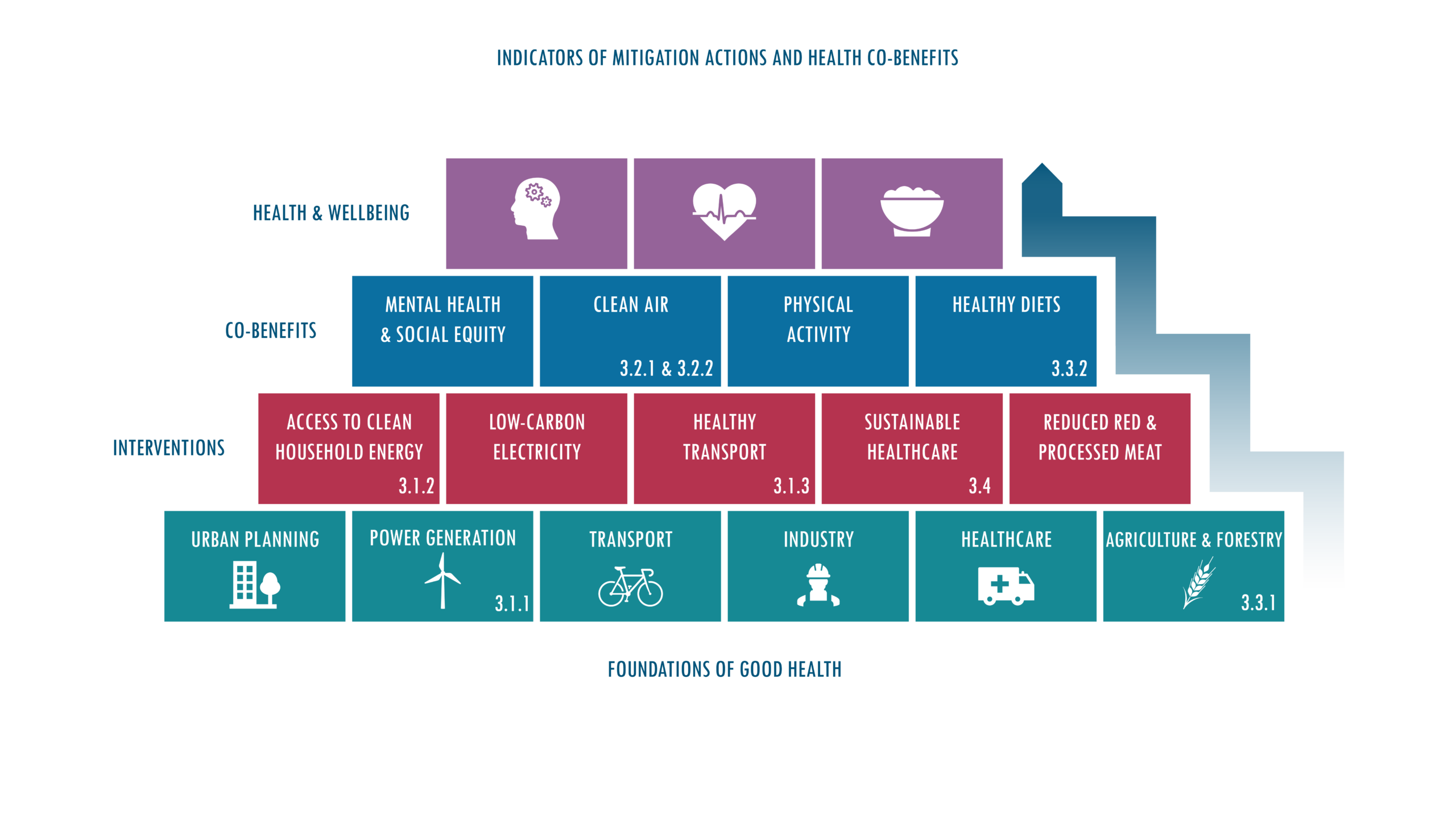
THE HEALTH BENEFITS OF THE RESPONSE TO CLIMATE CHANGE

Tackling climate change could be the greatest global health opportunity of the 21st century. Many of the interventions required to mitigate and adapt bring enormous benefits for human health and wellbeing in the form of cleaner air, healthier diets, and more liveable cities. Indicators in this section track the world’s efforts to mitigate climate change, and the health benefits of this response.

View fullscreen:

3.1 Energy Use, Energy Generation and Health

Energy systems are the largest single source of greenhouse gas emissions and are major contributors to air pollution. Coal combustion continues to be the largest contributor to emissions from the energy sector and is a major contributor to premature mortality due to air pollution. The phase-out of coal-fired power is therefore an important first step in the mitigation of climate change. Continued growth in renewable energy, particularly wind and solar sources, is key to replacing fossil fuels. This indicator monitors the transition of the global energy system.

View fullscreen:

Headline finding

CO2 emissions from fossil fuel combustion alone rebounded in 2021 by 4.8% after a 5.8% drop in 2020 due to COVID-19-related impacts.

Data sources

1. CO2 Emissions From Fuel Combustion: CO2 Indicators, 2021. International Energy Agency.

2. Global Energy Review: CO2 Emissions in 2020 and 2021. International Energy Agency.

3. 2021 Global Energy Review, 2021. International Energy Agency.

4. World Extended Energy Balances. International Energy Agency. Accessed in 2022.

Caveats

The carbon intensity component does not provide information on the share of different fossil fuels, their use in different sectors, and the absolute levels of usage. The coal phase-out and electricity data are unavailable for select countries; also data reported to International Energy Agency can be impacted by changes in reporting country methodologies.

This indicator was last updated in September 2022

Indicator description

This indicator tracks the carbon intensity of the energy system, both at global and regional scales, expressed as the CO2 emitted per terajoule of the total primary energy supply. This indicator also reports on progress towards a global phase-out of coal, tracking the total primary energy supply from coal and coal’s share of total electricity generation. Finally, this indicator tracks electricity generation and the share of total electricity generation from all low-carbon sources (nuclear and all renewables, including hydro) and renewables (wind and solar, excluding hydro and biomass).

3.1.1 Energy Systems and Health

Energy systems are the largest single source of greenhouse gas emissions and are major contributors to air pollution. Coal combustion continues to be a major contributor to emissions from the energy sector and is a major contributor to premature mortality due to air pollution. The phase-out of coal-fired power is therefore an important first step in the mitigation of climate change. Continued growth in renewable energy, particularly wind and solar sources, is key to replacing fossil fuels to increase access to clean energy and electricity generation for a more equitable and decentralised modern energy system. In pursuing these efforts, particular care is needed to avoid perpetuating harmful extractive industrial processes that disproportionately affect the health of minoritised communities and act to amplify – rather than reduce – global health inequities. This indicator monitors the transition of the global energy system.

View fullscreen:

Headline findings

CO2 emissions from the global energy system increased by 0.9% in 2022 due to reopening economies following the lift of COVID-19-related restrictions.

Data sources

1. CO2 Emissions From Fuel Combustion: CO2 Indicators, 2021. International Energy Agency.

2. Global Energy Review: CO2 Emissions in 2020 and 2021. International Energy Agency.

3. 2021 Global Energy Review, 2021. International Energy Agency.

4. World Extended Energy Balances. International Energy Agency. Accessed in 2022.

Caveats

International Energy Agency data are generated using both direct input from national governments and modelling. As such, while they represent the best available data on national CO2 emissions from fuel, they are subject to caveats which vary by energy commodity and country.

This indicator was last updated in September 2023

Indicator description

This indicator tracks the carbon intensity of the energy system, both at global and regional scales, expressed as the CO2 emitted per terajoule of the total primary energy supply from 1971-2020 and global CO2 emissions from energy combustion by fuel in GtCO2 from 1972-2020. This indicator also reports on progress towards a global phase-out of coal, tracking the total primary energy supply from coal and coal’s share of total electricity generation. Finally, this indicator tracks electricity generation and the share of total electricity generation from all low-carbon sources (nuclear and all renewables, including hydro) and renewables (wind and solar, excluding hydro and biomass).

Indicator authors

Dr Harry Kennard, Dr Matthew Winning

3.1.2 Household Energy Use

Access to stable, non-polluting energy is crucial for health and well-being. The use of unhealthy and unsustainable fuels and technologies for cooking, heating, and lighting in the home contributes both to greenhouse gas emissions and to dangerous concentrations of household air pollution. This indicator tracks the proportion of the population who use clean fuels and technologies for cooking and tracks types of energy usage in the residential sector.

View fullscreen:

Headline findings

Globally, only 32% of the domestic energy used per person is non-polluting at point of use, while 92% of the energy used in low HDI houses comes from polluting biofuels.

Data sources

1. Global Household Air Pollution (HAP) database, 2022. World Health Organization.

2. Global Household Energy Model: A Multivariate Hierarchical Approach to Estimating Trends in the use of Polluting and Clean Fuels for Cooking, 2020. Stoner, O et al.

3. World Extended Energy Balances, 2021. International Energy Agency. Accessed in 2023.

Caveats

The data from the International Energy Agency (IEA) on residential energy flows and energy access provide an indication of both the access to electricity and the proportion of the different types of energy used within the residential sector, providing a suggested picture on how access and use might be interacting. IEA data are generated using both direct input from national governments and modelling. As such, while they represent the best available data on national CO2 emissions from fuel, they are subject to caveats which vary by energy commodity and country.

This indicator was last updated in September 2023

Indicator description

This indicator draws on data from the IEA extended global residential modelling to monitor the sources of energy used in people’s homes, using WHO guidance to assess what fuels are “clean.”

Indicator authors

Prof Ian Hamilton, Prof Stella Hartinger, Dr Harry Kennard

3.1.3 Sustainable and Healthy Road Transport

Building cities and transport systems which move away from emitting vehicles and encourage cycling and physical activity can support climate change mitigation actions through reduced emissions and offer a route to maximise health benefits through improved public health from physical activity and reduction in air pollution. This indicator tracks fuel use for road transportation on a per capita basis, by fuel type.

View fullscreen:

Headline findings

Despite record growth in electric vehicle sales, fossil fuels still account for 95% of all road transport energy.

Data sources

1. World Extended Energy Balances, 2021. International Energy Agency. Accessed in 2023.

2. World Population Prospects 2022. United Nations Department of Economic and Social Affairs.

Caveats

This indicator captures change in total fuel use and type of fuel use for transport, it does not capture shifts in modes of transport used. In particular, it does not capture walking and cycling for short trips which can yield substantial health benefits through increased physical activity. Alongside the fossil fuel combustion pollutants, tyre wear accounts for an estimated 3-7% of airborne PM2.5 particulates worldwide.

This indicator was last updated in September 2023

Indicator description

This indicator captures change in total fuel use and type of fuel used for transport.

Indicator authors

Dr Harry Kennard, Dr Melissa Lott

3.2 Air Pollution and Health Co-benefits

View fullscreen:


3.2.1 Mortality from Ambient Air Pollution

Air pollution is responsible for several million premature deaths every year. Exposure to air pollution increases the risks of respiratory and cardiovascular diseases, cancer, diabetes, neurological disorders, and adverse pregnancy outcomes. Many of the major sources of of greenhouse gas emissions also contribute substantially to air pollution, presenting an opportunity for win-win actions. This indicator tracks global mortality attributable to ambient PM2.5 by sector and the potential health co-benefits of mitigation efforts that prioritise improved air quality.

View fullscreen:

Headline findings

Global deaths attributable to fossil fuel-derived PM2.5 decreased from 1.4 million in 2005 to 1.2 million in 2020. Reduced coal pollution contributed to about 80% of the decrease.

Data sources

1. World Extended Energy Balances, 2015. International Energy Agency. Accessed in 2023.

2. World Energy Outlook 2020 and 2021, 2021. International Energy Agency.

3. International Fertiziler Association Database, 2022. International Fertiziler Association.

4. World Population Prospects 2022. United Nations Department of Economic and Social Affairs.

5. Global Burden of Disease Study 2019 Particulate Matter Risk Curves, 2021. Institute for Health Metrics and Evaluation.

Caveats

Different dose-response relationships are used for Europe (recommended by World Health Organization-Europe) and the rest of the world. The non-linearity of the concentration-response functions used for non-European countries means that in highly polluted environments, the health benefits of a marginal reduction of emissions would be disproportionately smaller than the relative change in concentrations. The resolution of approximately seven to ten km is deemed appropriate for urban background levels of PM2.5 but may underestimate exposure in case of strong local PM2.5 increments.

This indicator was last updated in September 2023

Indicator description

This indicator models the premature deaths caused by air pollution from individual economic sectors, combining bottom-up emission calculations with atmospheric chemistry and dispersion coefficients and then applying this to population data and PM2.5 exposure-response relationships. This year, exposure-response relationships have been updated to be more consistent with the Global Burden of Disease 2019 study. It also highlights the contribution to premature deaths from coal across all sectors.


Indicator authors

Dr Gregor Kiesewetter, Laura Warnecke

3.2.2 Household Air Pollution

The use of dirty fuels in the household sector results in exposure to toxic concentrations of air pollution inside people’s, often poorly ventilated, homes. Globally, a concerning proportion of people still use polluting and inefficient fuels in the home for cooking, with women and girls often being tasked with indoor household energy-related activities and also with sourcing biomass, exposing them to violence and injuries and depriving them of time to access education and economic independence. This indicator tracks the use of polluting fuels in the homes and estimates attributable mortality.

View fullscreen:

Headline findings

The use of polluting fuels resulted in 140 deaths per 100,000 associated with household air pollution in 2020 in 62 countries reviewed, 56% of which was due to the use of solid fuels.

Data sources

1. Reducing Global Air Pollution: The Scope for Further Policy Interventions, 2020. Amann, M et al.

2. World Energy Outlook 2021, 2021. International Energy Agency.

3. Global Anthropogenic Emissions of Particulate Matter including Black Carbon, 2017. Kilmont, Z et al.

4. Earth Exchange Global Daily Downscaled Projections (NEX-GDDP), 2022. National Aeronautics and Space Administration.

5. Education index, United Nations Development programme, 2019.

6. Global Household Air Pollution (HAP) database, 2022. World Health Organization.

7. Household Air Pollution Attributable Death Rate (per 100 000 population), 2022. World Health Organization.

8. Indicator 7.1.2: Proportion of Population with Primary Reliance on Clean Fuels and Technology, 2019. World Health Organization.

9. Global Burden of 87 Risk Factors in 204 Countries and Territories, 1990–2019: A Systematic Analysis for the Global Burden of Disease Study 2019, 2020. GBD 2019 Risk Factors Collaborators.

10. Global Burden of Disease Study 2019 Results Tool. Institute for Health Metrics and Evaluation.

Caveats

This indicator may overestimate mortality through double counting by combining/overlapping ambient PM2.5 and household PM2.5 exposure. Indoor air pollution is complex and impacted by a number of factors including housing characteristics (e.g., ventilation, kitchen locations, window in kitchen, roofing materials) which are not typically captured in all the monitored data.

This indicator was last updated in September 2023

Indicator description

This indicator estimates exposure to household air pollution (HAP)-derived PM2.5 in 62 countries. It uses a Bayesian hierarchical model developed with sample data on indoor air quality from 282 peer-reviewed studies and accounts for socio-demographic and epidemiological characteristics and estimates attributable mortality through a comparative risk assessment.

Indicator authors

Prof Michael Davis, Shih-Che Hsu, Dr James Milner, Dr Nahid Mohajeri, Dr Jonathon Taylor

3.3 Food, Agriculture, and Health Co-benefits

View fullscreen:

Headline findings


Data sources


Caveats


Indicator description


3.3.1 Emissions from Agricultural Production and Consumption

Food systems contribute around 30% of global greenhouse gas emissions, most of which originate from meat and dairy livestock, remaining incompatible with mitigation targets. Although countries’ emissions are typically measured on a production basis, it is their consumption that generates the demand and results in diet-related health outcomes. This indicator tracks agricultural emissions from countries’ production and consumption.

View fullscreen:

Headline findings

Global agricultural emissions increased by 22% from 2000 to 2020, with red meat and dairy responsible for 57% of them in 2020.

Data sources

1. FAOSTAT database, 2022. Food and Agriculture Organization of the United Nations.

2. Variability, Drivers and Interactions of Key Environmental Stressors from Food Production Worldwide, 2019. Dalin, C et al.

3. Biomass Use, Production, Feed Efficiencies, and Greenhouse Gas Emissions from Global Livestock Systems, 2013. Herrero, M et al.

4. Greenhouse gas emissions intensity of global croplands, 2017. Carlson, KM et al.

Caveats

For livestock, some data are missing for some years, most notably Somalia (2000-2011) for non-dairy cattle, as well as data on grazing emissions from small islands is also missing. The emission factors differ from Food and Agriculture Organization numbers for livestock and for crops, due to methodology used. This indicator at present only considers the emissions associated with food production and does not take into account emissions associated with food transport and processing, storage and decomposition, use change and deforestation, it does consider emissions from cultivation of organic soils (such as peatland).

This indicator was last updated in September 2023

Indicator description

Compared to prior years, this indicator incorporates new classes of fruits, vegetables, nuts, pulses and legumes, and other crops tracked using data from the Food and Agriculture Organization of the United Nations. Their inclusion provides a more complete picture of the agricultural commodities used in the global food system. For a given year, the trade balances are corrected to take into account that a given commodity may have been produced in one country, processed in another, and finally imported into a third. Consumption refers to the net balance of food products entering a country within a given year, i.e., national production and net imports together. It does not refer to the total greenhouse gas emissions attributable to food consumed by individuals.


Indicator authors

Dr Carole Dalin, Dr Harry Kennard

3.3.2 Diet and Health Co-Benefits

Suboptimal diets are a leading risk factor for non-communicable diseases globally. A shift to healthier, more plant-based, and less carbon-intensive diets can substantially reduce greenhouse gas emissions and support major health benefits. This indicator presents the change in deaths attributable to dietary risk factors.

View fullscreen:

Headline findings

In 2020, 7.8 million deaths were associated with insufficient consumption of nutritious plant-based foods, and 1.9 million to excessive consumption of dairy, red and processed meat.

Data sources

1. Food Balance Sheets, 2019. Food and Agriculture Organization.

2. Global Food Losses and Food Waste: Extent, Causes and Prevention, 2011. Gustavsson, J et al., Food and Agriculture Organization of the United Nations.

3. Global Dietary Database 2017: Data Availability and Gaps on 54 Major Foods, Beverages and Nutrients among 5.6 million Children and Adults from 1220 Surveys Worldwide, 2021. Miller, V et al.

4. Trends in Adult Body-mass Index in 200 Countries from 1975 to 2014: A Pooled Analysis of 1698 Population-based Measurement Studies with 19·2 million Participants, 2016. NCD Risk Factor Collaboration.

5. Consumption of Nuts and Legumes and Risk of Incident Ischemic Heart Disease, Stroke, and Diabetes: A Systematic Review and Meta-analysis, 2014. Afshin, A et al.

6. Fruit and Vegetable Intake and the Risk of Cardiovascular Disease, Total Cancer and All-cause Mortality —A Systematic Review and Dose-response Meta-analysis of Prospective Studies, 2017. Aune, D et al.

7. Food Groups and Risk of Coronary Heart Disease, Stroke and Heart Failure: A Systematic Review and Dose-response Meta-analysis of Prospective Studies, 2019. Bechthold, A et al.

8. Food Groups and Risk of Colorectal Cancer, 2018. Schwingshackl, L et al.

9. Food Groups and Risk of Type 2 Diabetes Mellitus: A Systematic Review and Meta-analysis of Prospective Studies, 2017. Schwingshackl, L et al.

10. Nut Consumption and Risk of Cardiovascular disease, Total Cancer, All-cause and Cause-specific Mortality: A Systematic Review and Dose-response Meta-analysis of Prospective Studies, 2016. Aune, D et al.

11. Body-mass Index and All-cause Mortality: Individual-participant-data Meta-analysis of 239 Prospective Studies in Four Continents, 2016. The Global Mortality Collaboration.

12. Global Age-sex-specific Fertility, Mortality, Healthy Life Expectancy (HALE), and Population Estimates in 204 Countries and Territories, 1950–2019: A Comprehensive Demographic Analysis for the Global Burden of Disease Study 2019, 2020. Wang, H et al.
Caveats

The relative risks used are all supported by statistically significant dose-response relationships in meta-analyses and the existence of plausible biological pathways, however, there are caveats related to nutritional epidemiological studies, such as potential measurement error of dietary exposure. Evidence quality was graded with NutriGrade as moderate or high-quality evidence and the Nutrition and Chronic Disease Expert Group and World Cancer Research Fund graded the evidence for a causal association of 10 of the 12 risk factors as probable or convincing.

This indicator was last updated in September 2023

Indicator description

This indicator combines relative risk factors from a regularly updated meta-analysis, with population and mortality data to estimate the annual deaths attributable to dietary risk factors. As the analysis was primarily focused on mortality from chronic disease, the focus was on adults aged 20 and over with the relative-risk estimates adjusted for attenuation with age. Baseline food consumption was estimated by adopting estimates of food availability from the Food and Agriculture Organization of the United Nations’ food balance sheets, linking food consumption data disaggregated by sex and age and adjusted for food waste at point of consumption to estimate exposure.

Indicator authors

Dr Harry Kennard, Prof Marco Springmann

3.4 Healthcare Sector Emissions

Quality healthcare requires the use of energy, goods, services, and infrastructure, which all contribute to global greenhouse gas emission and mean the global healthcare sector still contributed over 4% of global greenhouse gas emissions in 2020. The healthcare sector has a responsibility to support adaptation efforts through resilience and providing quality care and simultaneously, it also has an important role in ambitious mitigation actions through reducing its own carbon emissions.

View fullscreen:

Headline findings

Increases in COVID-related healthcare spending in 2020 counterbalanced decreases in the carbon intensity of electricity, with global healthcare emissions remaining at 4.6% of total GHG emissions. Healthcare-associated PM2.5 and ozone were responsible for approximately 4 million Disability-Adjusted Life Years (DALYs) annually.

Data sources

1. EXIOBASE v3.8.3 model, year 2020.

2. Global Health Expenditure Database, 2020. World Health Organization.

Caveats

Since only total health expenditure data is available from World Health Organization, expenditures could not be separated as demand vs investment. Multi-Regional Input Output models are built from aggregated top-down statistical data – as such results do not reflect individual healthcare systems’ power purchase agreements for renewable energy or offsetting activities. Results do not include direct emissions of waste anaesthetic gases from clinical operations or emissions from metered-dose inhalers since these are not currently reported consistently in national emissions inventories.

New! Download the data

Click here to download the indicator data.

This indicator was last updated in September 2023

Indicator description

This indicator models emissions from the global healthcare sector by use of environmentally extended multi-region input-output models combined with data on healthcare expenditure from World Health Organization. New to this year, it also estimates healthcare-related emissions of PM2.5 and ozone precursors, and their health damages. It matches per-capita greenhouse gas emissions data with the United Nations Development Programme Human Development Index to report healthcare-associated greenhouse gas emissions per capita per year, including direct emissions from healthcare facilities as well as emissions from the consumption of goods and services supplied by other sectors.

Indicator authors

Dr Matthew Eckelman, Dr Jodi D. Sherman

Economics and Finance

The data here works to track the financial and economic dimensions of the effects of climate change, and of mitigation efforts required to respond to these changes. Indicators here monitor the economic costs of climate change and its drivers, as well as the investments and economic tools being deployed to transition to a low-carbon economy.

View fullscreen:

4.1 The Economic Impact of Climate Change and its Mitigation

The data here works to track the financial and economic dimensions of the effects of climate change, and of mitigation efforts required to respond to these changes. Indicators here monitor the economic costs of climate change and its drivers, as well as the investments and economic tools being deployed to transition to a low-carbon economy.

View fullscreen:

Headline Finding

In 2018, 831 climate-related extreme events resulted in US$166 billion in economic losses and no measurable losses in low-income countries were covered by insurance.

Indicator Description

This indicator tracks the total measurable annual economic losses (insured and uninsured) relative to GDP, resulting from climate-related extreme events.

Caveats

Where these are available, data is taken from official institutions, but where not, estimates are calculated. In cases where only low-quality information is available, such as a description of the number of homes damaged or destroyed, assumptions on value and costs are made.

This indicator was last updated in July 2019

Data Sources

– NatCatSERVICE, 2019. Munch Re

4.1.1 Economic Losses due to Weather-related Extreme Events

Climate-related extreme events can result in direct injury and death, increase the spread of water-borne diseases, and destroy habitats and infrastructure. Compounding this, these events often result in large economic costs, exacerbating the direct health impacts they produce through disruption of essential services and impacts on the socioeconomic determinants of health. This indicator tracks the insured and uninsured economic losses from weather-related exteme events, using data provided by Swiss Re.

View fullscreen:

Headline findings

Global economic losses due to weather-related extreme events were US$264 billion in 2022. While 57.1% of losses in very high HDI countries were insured, 92.8% of losses in other countries were uninsured.

Data sources

1. Sigma Explorer: Catastrophes Database, 2023. Swiss Re Institute.

2. World Economic Outlook Databases, 2022. International Monetary Fund.

Caveats

Only events with measurable economic losses above the threshold levels are included. Where these are available, data is taken from official institutions, but where not, estimates are calculated. In cases where only low-quality information is available, such as a description of the number of homes damaged or destroyed, assumptions on value and costs are made.

This indicator was last updated in September 2023

Indicator description

This indicator tracks the total annual economic losses (insured and uninsured) relative to gross domestic product that result from climate-related extreme events, referring to an event caused by natural forces. The scale of the losses resulting from a weather-related event depends not only on the severity, but also on man-made structures such as building design or the efficiency of the disaster response and control in the affected region. Total economic loses reported by Swiss Re are all the financial losses directly attributable to a major event – damage to buildings, infrastructure , vehicles etc – and also includes losses doe to business interruptions as a direct consequence of the property damage.

Indicator author

Dr Daniel Scamman

4.1.2 Value of Losses Due to Heat-related Mortality

Exposure to extremes of heat results in an increase in all-cause mortality, particularly in the over 65 population (indicator 1.1.5). As exposures to extremes of heat and the resulting health outcomes continue to rise, this indicator places a monetary value on heat-related mortality for the population 65-and-over.

View fullscreen:

Headline findings

At US$164 billion, the average annual monetised global losses due to heat related mortality for 2018-2022 were 146% higher than the 2000-2004 average.

Data sources

1. Heat-realted mortality data from indicator 1.1.5.

2. Population, Total, 2022. World Bank Group.

3. World average GDP per capita (USD), 2022. World Bank Group.

4. Inflation rate, yearly, 2022. World Bank Group.

5. Gross domestic product (GDP), 2021. Organisation for Economic Co-operation and Development (OECD).

6. Mortality Risk Valuation in Environment, Health and Transport Policies, 2012. Organisation for Economic Co-operation and Development (OECD).

7. World Health Organization methods and data sources for global burden of disease estimates 2000-2015, 2017. World Health Organization.

Caveats

Inequality embedded within the economic costs of heat-related mortalities across different social groups are ignored in this indicator due to lack of data. This indicator only considered the direct costs from mortalities of elder population, ignoring the potential costs that might derived from it. This indicator currently calculates Value of Statistical Life Year (VSLY) for different ageing groups using the same remaining life at death.

This indicator was last updated in September 2023

Indicator description

This indicator combines estimates on heat-related mortality from indicator 1.1.5 and the value of statistical life-year (VSLY) estimated for the member countries of the Organisation for Economic Cooperation and Development. It uses a fixed ratio of the VSLY to gross domestic product per capita. The value of mortality is presented as a dollar amount, a proportion of total gross domestic product, and as number of peoples’ incomes the loss would be equivalent to in a given country and region.

Indicator authors

Prof Wenjia Cai, Dr Shihui Zhang

4.1.3 Loss of Earnings from Heat-Related Labour Capacity Reduction

Heat exposure endangers the health of workers, reduces labour productivity, and generates income and economic losses which cascade through economies. This indicator quantifies the loss of earnings that could result from heat-related labour capacity loss, combining data from indicator 1.1.4 with hourly wage data from the International Labour Organization.

View fullscreen:

Headline findings

The global potential income loss from labour capacity reduction due to extreme heat was US$863 billion in 2022. The agricultural sector was the most severely affected, incurring 82% and 68% of the average losses in low and medium HDI countries, respectively.

Data sources

1. Potential working hours lost data from indicator 1.1.4.

2. International Labour Organization (ILO) International Statistics Database, 2021. ILO.

3. International Finance Statistics, 2021. International Monetary Fund.

4. World Economic Outlook Databases, 2021. International Monetary Fund.

5. Country and Lending Groups, 2022. World Bank.

Caveats

Results reflect potential loss of earnings in formal paid sectors, rather than actual loss, and do not include informal and unpaid labour that is significant in many countries. Such activites could include domestic work which disproportionately falls on women and small-scale agriculture. There are data gaps in the International Labour Organization Earnings and Labour Income dataset for the years studied for each country and thus several assumptions were incorporated in order to fill these data gaps. The indicator does not measure time off work actually taken.

This indicator was last updated in September 2023

Indicator description

This indicator combines data from indicator 1.1.4 on heat-related labour capacity loss, in terms of work hours lost (WHLs), at country scale across four sectors (services, manufacturing, constructon, and agriculture) with data on average earnings per hour per country, sector, and year. The total lost earnings are expressed as a percentage of the country’s GDP in each relevant year.

Indicator author

Dr Daniel Scamman

4.1.4 Costs of the Health Impacts of Air Pollution

Air pollution is responsible for several million deaths each year, resulting in profound economic costs. Efforts to mitigate climate change often reduce air pollution, resulting in significant cost-savings and a cost-effective intervention. This indicator tracks the costs of life lost from exposure to anthropogenic air pollution, many of which could be avoided through ambitious mitigation.

View fullscreen:

Headline findings

In 2020, the monetised costs of premature mortality due to air pollution amounted to US$2.2 trillion, the equivalent of 2.4% of gross world product

Data sources

1. Ambient air pollution death data from indicator 3.2.1.

2. World Population Prospects 2022. United Nations Department of Economic and Social Affairs.

3. World Economic Outlook Databases, 2021. International Monetary Fund.

Caveats

Inequality embedded within the economic costs of heat-related mortalities across different social groups are ignored in this indicator due to lack of data. This indicator only considered the direct costs from mortalities of elder population, ignoring the potential costs that might derived from it. This indicator currently calculates Value of Statistical Life Year (VSLY) for different ageing groups using the same remaining life at death.

This indicator was last updated in September 2023

Indicator description

This indicator estimates the change in Years of Life Lost (YLL) due to anthropogenic PM2.5 for 137 countries in 2005 and 2020. It combines data from indicator 3.2.1 and the value of statistical life-year (VSLY) estimated for the member countries of the Organisation for Economic Cooperation and Development (Organisation for Economic Co-operation and Development) using a fixed ratio of the value of VSLY to gross domestic product (gross domestic product) per capita. The value of mortality is presented a dollar amount, a proportion of total gross domestic product, and as number of peoples’ incomes the loss would be equivalent to in a given country and region.

Indicator authors

Dr Gregor Kiesewetter, Dr Daniel Scamman

4.2 The Economics of the Transition to Zero-Carbon Economies

View fullscreen:

Headline Finding

In Europe, improvements in particulate air pollution from human activity were seen from 2015 to 2016. If the levels of pollution for these two years remained the same over a person’s lifetime, this would lead to an annual average reduction in Years of Life Lost worth €5.2 billion.

Indicator Description

This indicator estimates the change in Years of Life Lost due to PM2.5 in European Union countries from 2015 to 2016, applied across 100 years to the 2015 population. A Value of a Life Year (€50,000) is then assigned to the Years of Life Lost to give an estimation of the annual average economic reduction of this change in PM2.5.

Caveats

Data is only available for EU countries and will be expanded in subsequent years. A Value of a Life Year of €50,000 is the lower bound estimate as suggested by the EU Impact Assessment Guidelines. This value does not take into account the health economic costs of healthcare delivery or societal economic costs such as workforce losses, thus representing an underestimation of real economic losses.

This indicator was last updated in July 2019

Data Sources

– Amann M, Bertok I, Borken-Kleefeld J, et al. Cost-effective control of air quality and greenhouse gases in Europe: Modeling and policy applications. Environmental Modelling & Software 2011; 26(12): 1489-501

– World Energy Outlook, 2017. IEA

4.2.1 Clean Energy Investment

Protecting health from a changing climate and realising the health co-benefits of climate action requires a zero-carbon and just transition of the whole global economy, and must include a rapid decline in the production and use of health-harming fossil fuels. Investing in zero-carbon energy and energy efficiency is essential for both mitigating climate change and for reducing air pollution. Reaching net-zero emissions can lead to economic growth, which in turn can lead to further investment in clean energy. This indicator monitors trends in global investment in energy supply and energy efficiency.

View fullscreen:

Headline findings

Global clean energy investment grew 15% in 2022, to US$1.6 trillion, and exceeded fossil fuel investment by 61%

Data sources

1. World Energy Investment, 2022. International Energy Agency.

Caveats

Investment estimates are derived from International Energy Agency data for energy demand, supply and trade, and estimates of unit capacity costs. Other areas of expenditure, including operation and maintenance, research and development, financing costs, mergers and acquisitions or public markets transactions, are not included.

This indicator was last updated in September 2023

Indicator description

This indicator draws on data from the annual International Energy Agency World Energy Investment to track energy supply investment. Key categories of investment are clean energy; fossil fuels; power sector; energy efficiency; and other supply, which includes investment in coal, natural gas, oil, and renewable energy supply for non-electricity purposes. It also uses the International Energy Agency data to assess 7 categories of energy investment: hydropower, bioenergy, other renewables (include solar and wind), nuclear power, energy efficiency, electricity networks and storage and fossil fuels.

Indicator authors

Dr Daniel Scamman

4.2.2 Employment in Renewable Energy and Fossil Fuel Industries

Employees in some fossil fuel extraction industries, particularly coal mining, and their local communities, have a greater incidence of cardiovascular and cerebrovascular disease, respiratory disease, and cancers than the general population. Investments in renewable energies and energy efficiency are estimated to create almost three times more jobs per unit of spend than investments in fossil fuel industries. This indicator uses data from IRENA and IBISWorld to compare employment in renewable energy and fossil fuel extraction.

View fullscreen:

Headline findings

Direct and indirect employment in renewable energy grew 5.6% in 2021 to a record-high of nearly 12.7 million employees, while direct employment in fossil fuel extraction increased by nearly 20%

Data sources

1. Renewable Energy and Jobs, Annual Review 2021, 2021. International Renewable Energy Agency.

2. Global Coal Mining, 2022. IBISWorld.

3. Global Oil & Gas Exploration & Production, 2022. IBISWorld.

Caveats

Fossil fuel extraction values include direct employment, whereas renewable energy jobs include direct and indirect employment (e.g., equipment manufacturing), with the exception of hydropower. At the time of writing, 2021 data on employment in the renewables sector was unavailable.

This indicator was last updated in September 2023

Indicator description

This indicator draws on International Renewable Energy Agency and IBISWorld to track the number of jobs in renewable and fossil fuel extraction sectors, respectively.

Indicator author

Dr Daniel Scamman

4.2.3 Funds Divested from Fossil Fuels

By reducing financial interests in the fossil fuel industry, divestment both reduces the social licence of fossil fuel companies and hedges against investors’ risk of losses due to so-called stranded assets in an increasingly decarbonising world. Healthcare institutions can take a lead in divesting holdings in fossil fuel companies, advancing their mission to protect health; public health institutions have a long history of divesting from products that harm the health of their patients – tobacco, alcohol, or arms. This indicator tracks the value of funds divested from fossil fuels using data provided by stand.earth.

View fullscreen:

Headline findings

Between 2008 and the end of 2022, the global value of funds committed to fossil fuel divestment was US$40.51 trillion, with healthcare institutions accounting for US$54 billion.

Data sources

1. Global Fossil Fuel Divestment Commitments Database, 2022. Stand.earth.

Caveats

Data on the number of institutions that have divested, and the value of their assets is dependent on self-reporting by the institutions to stand.earth. Due to confidentiality issues, the value of funds divested by each organisation is not available. The year of divestment reflects the year when the commitment was recorded in stand.earth.

This indicator was last updated in September 2023

Indicator description

This indicator tracks the total global value of funds divested from fossil fuels, and the value of divested funds coming from health institutions, using self-reported data from stand.earth.

Indicator author

Dr Daniel Scamman

4.2.4 Net Value of Fossil Fuel Subsidies and Carbon Prices

Carbon prices can help economies transition away from high-carbon fuels and drive the transition towards a low-carbon economy, working in contrast to fossil fuel subsidies that provide incentives for health-harming emissions and which slow down the low-carbon transition. As the world works to move away from health-harming fossil fuel use, this indicator compares carbon pricing and monetary fossil fuel subsidies to calculate net economy-wide average carbon prices and revenues, covering 87 countries that emit 93% of global CO2 emissions.

View fullscreen:

Headline findings

78% of the 87 countries reviewed had a net-negative carbon price in 2020, generating a net subsidy to fossil fuels of US$305 billion. The value of the resulting net subsidies exceeded 10% of national health budgets in nearly 30% of these countries

Data sources

1. Energy Subsidies – Tracking the Impact of Fossil Fuel Subsidies, 2021. International Energy Agency.

2. OECD Inventory of Support Measures for Fossil Fuels, 2021. Organisation for Economic Co-operation and Development.

3. World Bank Carbon Pricing Dashboard, 2021. World Bank Group.

4. Greenhouse Gas Emissions from Energy, 1751-2020, 2021. International Energy Agency.

5. Global Health Expenditure Database, 2020. World Health Organization.

6. World Economic Outlook Databases, 2021. International Monetary Fund.

Caveats

The economy-wide net carbon price was derived by dividing fossil fuel subsidies and carbon pricing revenues by total CO2 emissions. This fits well with the subsidies, as these are for fossil fuels, the principal source of CO2. However, some of the carbon pricing instruments from which the revenue was assessed are not only for fossil fuel combustion but apply to other sectors and non-CO2 gases.

This indicator was last updated in September 2023

Indicator description

This indicator calculates net, economy-wide average carbon prices and associated net carbon revenue to the government. The calculations are based on the value of overall fossil fuel subsidies (taking into account both budgetary transfers and tax expenditures), the revenue from carbon pricing mechanisms, and the total CO2 emissions of the economy. Positive results indicate a net tax on CO2 emissions, while negative results indicate a net subsidy for fossil fuels.

Indicator author

Dr Daniel Scamman

4.2.5 Production-based and Consumption-based Attribution of CO2 and PM2.5 Emissions

The production of goods and services drives both greenhouse gas and PM2.5 emissions contributing to impacts on health and wellbeing. A comparison of production- and consumption-based emissions gives a better understanding of how emissions are embodied in global trade, with consumption-based emissions accounting allocating emissions to countries according to their consumption of goods and services even when the physical emissions occurred abroad. As the world works towards net-zero emissions, this indicator tracks the pollution burden from a country’s local production and final consumption.

View fullscreen:

Headline Finding

In 2021, 4.2% and 5.2% of global CO2 and PM2.5 emissions occurred in low, medium or high HDI countries due to the net import of goods and services consumed in very high HDI countries

Data sources

1. EXIOBASE 3: Developing a Time Series of Detailed Environmentally Extended Multi-Regional Input-Output Tables, 2018. stadler, K et al.

2. Global Carbon Project 2021, 2021. Friedlingstein, P et al.

3. World Bank Open Data database, 2022. World Bank Group.

4. Greenhouse Gas and Air Pollution Interactions and Synergies (GAINS), 2021. International Institute for Applied Systems Analysis.

5. Emissions Database for Global Atmospheric Research (EDGAR) database, 2022. European Commission.

Caveats

GAINS process emissions are only distributed across MRIO sectors that can be clearly identified. Trucking-related emissions are distributed among all sectors based on diesel consumption. Simplifications and assumptions made during the emission inventory disaggregation stage may bring uncertainties into the results.

This indicator was last updated in September 2023

Indicator description

This indicator uses an environmentally-extended multi-region input-output (EEMRIO) model to quantify countries consumption-based and production-based contribution to CO2 and PM2.5. The EEMRIO analysis reflects production and consumption structures and interdependencies between economic sectors across regions, estimating PM2.5 and CO2 emissions embodied in international trade, and calculating national PM2.5 and CO2 emissions from the consumption perspective.

Indicator authors

Kehan He, Prof Zhifu Mi, Dr Fabian Wagner

4.2.6 Compatibility of Fossil Fuel Company Strategies With the Paris Agreement

Emissions from oil and gas need to be reduced dramatically to keep global mean temperature rise below 1.5°C, and enable a healthy future. This indicator assess the alignment of current oil and gas company production strategies with the Paris Agreement goals using data on actual commercial activities from the Rystad Energy database for the 20 largest oil and gas companies and their projected 2040 production.

View fullscreen:

Headline finding

The strategies of the 20 largest oil and gas companies as of February 2023 would lead to production exceeding levels consistent with 1.5°C of heating by 173% in 2040, an increase from 112% expected as from February 2022

Data sources

1. World Energy Outlook 2021, 2021. International Energy Agency.

2. UCube Database, 2022. Rystad Energy.

3. Key World Energy Statistics 2021, 2021. International Energy Agency.

Caveats

Even if oil and gas firms follow the Paris-compliant pathways outlined here, there is still a substantial chance that temperature targets will be exceeded. Oil and gas firms are assumed here to have constant market shares. This assumption is typical for this sort of analysis but can be expected to introduce errors for at least some firms that increase over time. These uncertainties are likely to increase over time, meaning projections in the long-term are less certain than in the shorter-term.

This indicator was last updated in September 2023

Indicator description

The indicator tracks the gap between the projected production of oil and gas companies based on their actual activities, and production trajectories consistent with the Paris target of 1.5°C of heating. The indicator is expressed as a percentage of the projected production of each company is above or below a pathway consistent with the Paris targets. The indicator analyses both international, publicly traded oil companies and national oil companies, which in many cases have larger production volumes than IOCs but are subject to less public or shareholder scrutiny.

Indicator author

Dr Daniel Scamman

4.2.7 Fossil Fuel and Green Bank Lending

Redirecting finance away from fossil fuels and towards clean renewable, energy efficiency, and carbon sinks is essential for a healthy, just transistion to net-zero emissions. The Net-Zero Banking Alliance (NZBA) was convened by United Nations Environment Programme in 2021 to promote this financial shift. This indicator draws on Bloomberg data to monitor private banks’ lending to the fossil fuel sector and the green sector. A financial transformation will be essential to overhaul investments from fossil fuels to clean renewable energy sources; this will support countries responding to energy crises, reduce air pollution, and secure a healthy, equitable future.

View fullscreen:

Headline findings

Green sector lending has risen sharply since 2016, to US$498 billion in 2021, and is approaching fossil fuel lending. However, 22 of the top 40 private banks have increased their fossil fuel lending

Data sources

1. Fossil fuel and green fixed income data. 2022. Bloomberg.

2. Net Zero Banking Alliance. 2023

Caveats

This data only represents a subset of investments provided by the financial sector – equity investments are not covered by the data, nor are contributions from other financial actors such as institutional investors. In addition, the labelling of a debt as ‘green’ is reliant on the classification by the issuer, which makes it susceptible to green-washing as there is no independent verification of the classification.

This indicator is new to 2023

Indicator description

Data for bank lending to the fossil fuel and green sectors was taken from a proprietary Bloomberg dataset covering the global debt market. Fossil fuel lending is defined as being directed towards exploration, production, operation and marketing activities in oil and gas. Green lending is self-identified by the issuer as funding for a project or activity with an environmental or sustainability-oriented goal.

Indicator authors

Dr Nadia Ameli, Dr Francesca Larosa, Dr Jamie Rickman

Public and Political Engagement in Health and Climate Change

Public and political engagement underpins the foundations of the world’s collective response to climate change, with reductions in global emissions at the speed required by the Paris Agreement depending on engagement from all sectors of society. The indicators in this section track the links between health and climate change in the media, national governments, the corporate sector, and the broader public.

View fullscreen:

5.1 Media Engagement in Health and Climate Change

Traditional media outlets (newspaper, radio, and television) continue to provide a major platform for public engagement, and play an important role in agenda-setting within today’s multi-media landscape. Newspapers can shape public understanding of climate change, both through their influence on their readers and the wider political agenda. This indicator tracks coverage of health and climate change in 66 newspapers in 36 countries, including China’s People’s Daily.

View fullscreen:

Headline findings

In 2022, global newspaper coverage of health and climate change continued its upward trend, reaching a record 28% of all climate change articles mentioning health

Data sources

1. Nexis Uni® database.

2. Factiva© database.

3. ProQuest LLC database.

4. People’s Daily official website.

Caveats

The selected newspapers cannot be taken to be representative of all media reporting in their countries, and the content analysis does not reflect the ways in which climate change and/or health is reported in the media, nor the general messaging. The search terms used are likely to have influenced the types of articles obtained, and databases might return hits of duplicate articles.

In developing the search strategy for the 2020 and 2021 Lancet Countdown report, it was found that a significant portion of articles may mention both climate change and health but do not engage with them as integrated issues. Including this coverage remains important as it brings both sets of issues – health and climate change – onto the public agenda and into public awareness.

This indicator was last updated in September 2023

Indicator description

Articles from 2007 to 2021 in 66 newspapers across 36 countries, written in English, German, Portuguese and Spanish were analysed using key word searches within three databases. Additionally, articles in Chinese in China’s People’s Daily were assessed through a process of first trawling through all articles and then searching for keywords in article text.

Indicator authors

Dr Lucy McAllister, Prof Wenjia Cai, Dr Pete Lampard, Olivia Pearman

5.2 Individual Engagement in Health and Climate Change

Online activity is increasingly being used to understand and drive public and individual engagement, transforming individual access to global knowledge and debates. This indicator tracks individuals’ information-seeking behaviour on Wikipedia in relation to the link between climate change and health. With content on Wikipedia created and edited by users, it can influence the agenda of other media sources.

View fullscreen:

Headline findings

Individual engagement with health and climate change remained low in 2022. Of all clickviews that led to health-related articles, only 0.03% came from climate change-related articles; and only 0.36% of clickviews that led to climate change-related articles came from health-related articles

Data sources

1. Wikimedia Dumps, 2022. Wikimedia Foundation

Caveats

The data is not geo-referenced, so it is not possible to infer the location of page visits. Only English Wikipedia pages were considered in the analysis (approximately 50% of total Wikipedia pages), and while they are accessed globally, it is biased towards English-speaking countries.

This indicator was last updated in September 2023

Indicator description

This indicator measures the number of clicks from health-related Wikipedia articles that lead to visits to climate change-related Wikipedia articles, and the number of visits to climate change-related articles that result in clicks to health-related pages from 2018-2022. This ‘clickstream data’ is used as a proxy for the degree to which individuals engage with health and climate change as related issues.

Indicator author

Prof Simon Munzert

5.3 Scientific Engagement in Health and Climate Change

Peer-reviewed scientific journals are the premier source of high-quality research that provides evidence used by the media, the government, and the public. This indicator tracks scientific engagement with health and climate change in peer-reviewed journals.

View fullscreen:

Headline findings

The number of scientific papers investigating health and climate change increased by 22% from 2020 to 2021.

Data sources

1. Web of Science database, 2022.


2. Scopus database, 2022.


3. MEDLINE database, 2022.

Caveats

The use of machine learning means that there will be some uncertainty as to the number of relevant documents. The quality of the data and the specifics of its content are not assessed, however, with the outputs all published in peer-reviewed journals, there is a de facto quality check. For this reason, the indicator does not cover grey literature.

This indicator was last updated in September 2022

Indicator description

This indicator identifies original research articles and research-related articles published from 2007 to 2021 that cover health and climate change topics using a machine-learning approach. This allowed for a more granular picture of the research landscape, including developments across major domains of research (mitigation, adaptation, impacts), the health impacts covered, locations studied, as well as patterns of authorship.

5.3.1 Scientific Articles on Health and Climate Change 1990-2022

Peer-reviewed scientific journals are the premier source of high-quality research that provides evidence used by the media, the government, and the public. This indicator tracks scientific engagement with health and climate change in peer-reviewed journals using machine learning methodology to monitor the number of peer-reviewed scientific articles on health and climate.

View fullscreen:

Headline findings

After rapid growth in 2020 and 2021, the number of scientific papers investigating the links between health and climate change in 2022 fell by 2% compared to 2021, but remained three times higher than in 2012

Data sources

1. Web of Science database, 2022.

2. Scopus database, 2022.

3. MEDLINE database, 2022.

Caveats

The use of machine learning means that there will be some uncertainty as to the number of relevant documents. The quality of the data and the specifics of its content are not assessed; however, with the outputs all published in peer-reviewed journals, there is a de facto quality check. For this reason, the indicator does not cover grey literature.

This indicator was last updated in September 2023

Indicator description

This indicator identifies original research articles and research-related articles published from 2007 to 2022 that cover health and climate change topics using a machine-learning approach. This allowed for a more granular picture of the research landscape, including developments across major domains of research (mitigation, adaptation, impacts), the health impacts covered, locations studied, as well as patterns of authorship.

Indicator auhtors

Prof Lea Berrang Ford, Dr Max Callaghan, Prof Jan C. Minx

5.3.2 Scientific Engagement on the Health Impacts of Climate Change

New to this year’s report is a subindicator building on indicator 5.3.1, that captures health impacts that can tentatively be attributed to climate change, using different methods to estimate these climate-related health impacts. This indicator maps the volume of studies published between January 1985 and December 2022 referring to health impacts related to climate variables, where changes in the climate driver can be attributed to human influence.

View fullscreen:

Headline findings

There are global inequalities in the location of studies referring to the health impacts of human-influenced climate drivers: 6.89 studies per million people in very high HDI countries, and 1.61 and 1.51, respectively, for medium and low HDI countries. Of 37 extreme events analysed for detection and attribution between 2022 and 2023, 31 (84%) were more likely and/or more severe because of climate change

Data sources

1. World Weather and Attribution and American Metereological Society.

2. Web of Science database, 2022.

3. Scopus database, 2022.

4. EM-DAT: The International Disaster Database. Centre for Research on the Epidemiology of Disasters. Accessed in 2023.

Caveats

This indicator is limited by the number of published attribution studies and their chosen focus. As past detection and attribution studies have predominately focussed on events occurring in more developed regions, the paucity of data relating to the health impacts of attributable events in less developed regions is recognised. Measures of morbidity are multiple and varied, which can constrain the data analysis, thereby limiting interpretations.

This indicator is new to the 2023 report

Indicator description

This indicator categorises extreme climate events from attribution studies according to the relative impact of anthropogenic climate change on their likelihood and/or extermity, and the corresponding mortality and morbidity impacts. Each event is categorically considered a) more likely or severe due to climate change, b) less likely or severe due to climate change, or c) the impact of climate change on likelihood or severity is neutral or unclear. Detection and attribution is widely used within public health as a means of charaterising and quantifying curent health impacts and future risk.

Indicator authors

Prof Kathryn Bowen, Grant Silbert

5.4 Political Engagement in Health and Climate Change

Meeting the commitments under the Paris Agreement requires accelerated and ambitious interventions from governments across the world. Ensuring these efforts maximise human health and wellbeing begins with these issues being recognised as important areas of concern, and as reasons for change. This indicator tracks references to health and climate change in the speeches of global leaders at the United Nations General Debate at the General Assembly, the key event for Member States to speak about their nations’ priorities and concerns, as well as references to health in the nationally determined contributions to the Paris Agreement.

View fullscreen:

Headline findings

The proportion of countries referring to the health-climate change nexus increased in both the 2021 United Nations General Assembly (to 60%) and in updated nationally determined contribution submissions (to 86%).

Data sources

1. Understanding State Preferences With Text As Data: Introducing the UN General Debate Corpus, 2017. Batuor, A et al.


2. Nationally Determined Contributions Registry, 2022. United Nations Framework Convention on Climate Change.

Caveats

The results present a somewhat conservative estimate of high-level political engagement with the intersection of climate change and health. There may be examples of governments referring to climate change and health but not the direct linkages between the two and there may be examples of governments discussing the health impacts of climate change in their United Nations General Debate speeches but the distance between the climate change term and the health term exceeds 25 words. The analyses are based on a narrow range of search terms, which excludes reference to many of indirect links between climate change and health.

This indicator was last updated in September 2022

Indicator description

This indicator tracks government engagement in health and climate change in two key forums. It assesses reference to health and climate change as well as their prominence in the text of all available (up until 2021) Nationally Determined Contributions by Parties to the Paris Agreement. It also tracks mentions of climate change and health in statements made by national leaders at the United Nations General Debate, which is part of the annual United Nations General Assembly, as proxy of high-level political engagement on these two topics as separate and related issues.

5.4.1 Government Engagement

Engagement by political leaders is central to accelerated and ambitions climate interventions that protect human health. This indicator monitors political engagement through national leaders’ statements at the UN General Debate (UNGA), the cornerstone of the annual UNGA, and Nationally Determined Contributions (NDCs), the key policy instrument to protect people and the planet from climate change. As the world warms and the impacts of climate change are being felt globally, it is essential these issues are being recognised as important areas of concern and prompts for change.

View fullscreen:

Headline findings

50% of countries mentioned the intersection of health and climate change at the UN General Debate in 2022, a 10% decrease from 2021. 95% of updated NDC documents make reference to health, up from 73% in the first submission

Data sources

1. Understanding State Preferences With Text As Data: Introducing the UN General Debate Corpus, 2017. Batuor, A et al.

2. Nationally Determined Contributions Registry, 2022. United Nations Framework Convention on Climate Change.

Caveats

The results present a somewhat conservative estimate of high-level political engagement with the intersection of climate change and health. There may be examples of governments referring to climate change and health but not the direct linkages between the two and there may be examples of governments discussing the health impacts of climate change in their United Nations General Debate speeches but the distance between the climate change term and the health term exceeds 25 words. The analyses are based on a narrow range of search terms, which excludes reference to many of indirect links between climate change and health.

This indicator was last updated in September 2023

Indicator description

This indicator tracks government engagement in health and climate change in two key forums. It assesses reference to health and climate change as well as their prominence in the text of all available (through February 2023) Nationally Determined Contributions by Parties to the Paris Agreement. It also tracks mentions of climate change and health in statements made by national leaders at the United Nations General Debate, which is part of the annual United Nations General Assembly, as proxy of high-level political engagement on these two topics as separate and related issues.

Indicator authors

Dr Niheer Dasandi, Prof Slava Jankin, Dr Pete Lampard

5.4.2 Engagement by International Organisations

International Organisations (IOs) – for example, international and regional development agencies, supra-national bodies like the EU, African Union and UN agencies – are playing an increasingly important role in climate change action. This indicator tracks engagement in the health co-benefits of climate mitigation in IOs’ official Twitter accounts, a key mode of communication with journalists and the public.

View fullscreen:

Headline findings

Tweets mentioning the health co-benefits of climate change action reached a record of 22% of all monthly tweets from International Organisations in November 2022, in a continuously upward trend

Data sources

1. Geolocated Tweets collected via the Twitter Streaming Application Programming Interface. Accessed in 2023.

Caveats

This indicator works with a limited predefined set of international organisations, and search terms could be missing parts of co-benefits discussions.

This indicator is new to 2023 report

Indicator description

Natural language processing (a subfield of machine learning) is used here to track the uptake and engagement of health co-benefits in policy discourse on social media of major international organisations (IOs) involved in climate change adaptation and mitigation work. With the dataset of IO’s tweets, a search through the text of each tweet was performed to identify if they discuss co-benefits. An indicator of engagement intensity was developed as a monthly proportion of tweets containing at least one term from the search term list in relation to the total number of tweets by that IO.

Indicator authors

Dr Olga Gasparyan, Prof Slava Jankin, Prof Cathryn Tonne

5.5: Corporate Sector Engagement in Health and Climate Change

The corporate sector is central to the transition to a low-carbon economy, both through its own behaviour and greenhouse gas emissions and its wider political influence. This indicator tracks engagement with health and climate change in healthcare companies within the United Nations Global Compact, the world’s biggest corporate sustainability framework.

View fullscreen:

Headline findings

Corporate sector engagement with health and climate change reached its highest recorded level in 2022, with 38% of companies referring to the health dimensions of climate change

Data sources

1. Communication on Progress (CoP) portal, 2022. United Nations Global Compact.

Caveats

This analysis is based on a narrow range of search terms, which excludes reference to many of indirect links between climate change and health, such as the effect of climate change on agriculture. Therefore, the results present a somewhat conservative estimate of high corporate engagement with the intersection of climate change and health.

This indicator was last updated in September 2023.

Indicator description

This indicator monitors engagement on health and climate change from the over 20,000 companies from 162 countries who signed up to the UNGC by tracking mentions of health and climate change in their annual Global Compact Communication of Progress (GCCOP) reports.

Indicator authors

Dr Niheer Dasandi, Prof Slava Jankin